Toggle navigation
LMEC Home
Exhibitions
Georeferencing
Tools for Teachers
Collections
My Favorites
Sign Up / Log In
Search
Search the map portal
Map Collection
Map Collection
Map Sets
Search
Search
Search for
Search In
All Fields
Creator
Title
Subject
Place
Search All Digital Collections
Advanced Search
519 Results
My Search
Start Over
More Like
commonwealth:xw42qq50k
Remove constraint More Like: commonwealth:xw42qq50k
Filter your Search
Place
North and Central America
516
United States
513
Suffolk (county)
506
Boston
505
Massachusetts
202
Roxbury
90
South End
51
Fens
48
more
Place
»
Topic
City planning--Massachusetts--Boston--Maps
418
Urban renewal--Massachusetts--Boston--Maps
253
Boston (Mass.)--Maps
140
Land use--Massachusetts--Boston--Maps
101
Roxbury (Boston, Mass.)--Maps
89
Buildings--Massachusetts--Boston--Maps
85
Real property--Massachusetts--Boston--Maps
77
Fenway (Boston, Mass.)--Maps
49
more
Topic
»
Date
Date range begin
–
Date range end
Current results range from
1832
to
2003
View distribution
Creator
Boston Redevelopment Authority
368
Bromley, George Washington
17
Bromley, Walter Scott
17
G.W. Bromley & Co.
12
Downtown Waterfront Corporation
10
Victor Gruen Associates
10
Boston (Mass.). Parks and Recreation Department
8
Sasaki Associates
6
more
Creator
»
Format
Maps/Atlases
518
Drawings/Illustrations
3
Manuscripts
1
Prints
1
Georeferenced
Yes
6
No
513
Collection
Boston and New England Maps
505
Urban Maps
489
Boston Redevelopment Authority Collection
442
Norman B. Leventhal Map & Education Center Collection
129
Massachusetts Real Estate Atlases
4
Applied Geographics, Inc. Records
1
Mapping Boston Collection
1
Available to use
No known restrictions
513
Creative Commons license
1
Search Constraints
Sort by relevance
relevance
title
date (asc)
date (desc)
Number of results to display per page
20 per page
10
per page
20
per page
50
per page
100
per page
View results as:
grid view
map view
Search Results
201.
Government Center parcel 8 office tower competition program
202.
Government Center project Mass. r-35 : parcel 7 & subway structure topographic map
203.
Government Center project Mass. r-35 : property line map
204.
Government Center project no. Mass. r-35 : building deficiencies map
205.
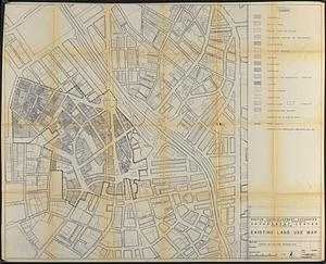
Government Center project no. Mass. r-35 : existing land use map
206.
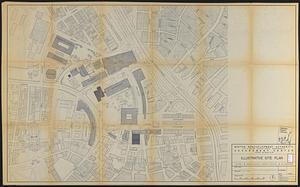
Government Center project no. Mass. r-35 : illustrative site plan
207.
Government Center project no. Mass. r-35 : disposition parcel map
208.
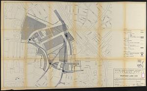
Government Center project no. Mass. r-35 : proposed land use
209.
Government Center project no. Mass. r-35 : proposed land use map
210.
Government Center project no. Mass. r-35 : subway adjustments plan
211.
Government Center redevelopment project : land use map
212.
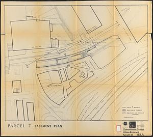
Government Center urban renewal area r-35 : parcel-7 easement plan
213.
Government Center urban renewal area r-35 parcel-7 : site section 1
214.
Government Center urban renewal area r-35 parcel-7 : site section 2
215.
Hancock Woods : as of right plan
216.
Hancock Woods EGA
217.
The Harbor Park system
218.
Herald Street improvements
219.
Illustrative re-use site plan for the regional core
220.
Illustrative site plan : Government Center
‹ Prev
Next ›
1
2
…
7
8
9
10
11
12
13
14
15
…
25
26