Toggle navigation
LMEC Home
Exhibitions
Georeferencing
Tools for Teachers
Collections
My Favorites
Sign Up / Log In
Search
Search the map portal
Map Collection
Map Collection
Map Sets
Search
Search
Search for
Search In
All Fields
Creator
Title
Subject
Place
Search All Digital Collections
Advanced Search
8696 Results
My Search
Start Over
More Like
commonwealth:xg94j181j
Remove constraint More Like: commonwealth:xg94j181j
Filter your Search
Place
North and Central America
5,926
United States
4,844
Massachusetts
2,079
Europe
1,397
Suffolk (county)
1,046
Boston
1,019
Canada
449
Asia
438
more
Place
»
Topic
Boston (Mass.)--Maps
586
United States--Maps
282
Real property--Massachusetts--Boston--Maps
175
Massachusetts--Maps
162
Landowners--Massachusetts--Boston--Maps
133
North America--Maps--Early works to 1800
103
New England--Maps
102
Europe--Maps
79
more
Topic
»
Date
Date range begin
–
Date range end
Current results range from
1482
to
2023
View distribution
Creator
United States. Hydrographic Office
595
O.H. Bailey & Co
148
Des Barres, Joseph F. W. (Joseph Frederick Wallet), 1722-1824
123
United States. Post Office Dept
120
Ptolemy, 2nd cent
100
Walling, Henry Francis, 1825-1888
94
Geological Survey (U.S.)
86
Jefferys, Thomas, -1771
85
more
Creator
»
Format
Maps/Atlases
8,634
Manuscripts
215
Prints
56
Books
38
Objects/Artifacts
10
Drawings/Illustrations
8
Posters
5
Georeferenced
Yes
869
No
7,827
Collection
Norman B. Leventhal Map & Education Center Collection
8,694
Boston and New England Maps
2,233
Urban Maps
2,023
Maritime Charts and Atlases
1,083
American Revolutionary War-Era Maps
616
Boston Redevelopment Authority Collection
87
U.S. Government Documents Maps Collection
2
Available to use
No known restrictions
8,554
Creative Commons license
47
Search Constraints
Sort by relevance
relevance
title
date (asc)
date (desc)
Number of results to display per page
20 per page
10
per page
20
per page
50
per page
100
per page
View results as:
grid view
map view
Search Results
21.
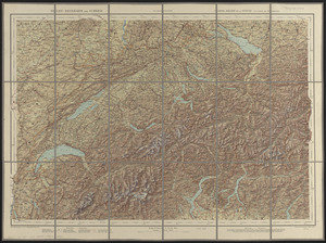
Relief-reisekarte der Schweiz = Carte-relief de la Suisse à l'usage des touristes
22.
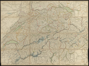
Schweiz
23.
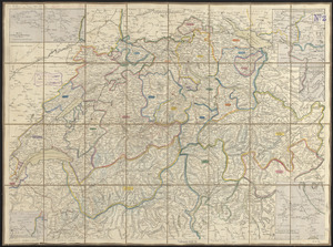
Schweiz
24.
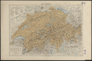
Die Schweiz
25.
Switzerland according to the best authorities
26.
Carta d'Italia : alla scala di la 800,000
27.
Carta geografica e postale dell' Italia ridotta dalle migliori carte fin' ora esistenti coll' indicazione di tutte le strade...
28.
Carta statistica e postale dell'Italia
29.
Carte physique & routière de l'Italie indiquant les distances d'un relais à l'autre et les dernières divisions politiques
30.
Charte von Italien : Nach seiner neuesten Eintheilung und den vorzüglichsten Hülfsmitteln
31.
Hammond's large scale war map of the Italian Front
32.
L'Italia
33.
Italia cum insulis et regionibus finitimis
34.
Italie
35.
Italy
36.
Italy
37.
Italy
38.
Italy
39.
Italy, and Sardinia, from the best authorities
40.
Italy with Vatican City
‹ Prev
Next ›
1
2
3
4
5
6
…
434
435