Toggle navigation
LMEC Home
Exhibitions
Georeferencing
Tools for Teachers
Collections
My Favorites
Sign Up / Log In
Search
Search the map portal
Map Collection
Map Collection
Map Sets
Search
Search
Search for
Search In
All Fields
Creator
Title
Subject
Place
Search All Digital Collections
Advanced Search
8868 Results
My Search
Start Over
More Like
commonwealth:x633fb834
Remove constraint More Like: commonwealth:x633fb834
Filter your Search
Place
North and Central America
6,099
United States
5,015
Massachusetts
2,137
Europe
1,396
Suffolk (county)
1,214
Boston
1,187
Canada
449
Asia
438
more
Place
»
Topic
Boston (Mass.)--Maps
752
United States--Maps
282
Real property--Massachusetts--Boston--Maps
197
Massachusetts--Maps
166
City planning--Massachusetts--Boston--Maps
164
Landowners--Massachusetts--Boston--Maps
143
New England--Maps
104
North America--Maps--Early works to 1800
103
more
Topic
»
Date
Date range begin
–
Date range end
Current results range from
1482
to
2023
View distribution
Creator
United States. Hydrographic Office
595
Boston Redevelopment Authority
168
O.H. Bailey & Co
148
Des Barres, Joseph F. W. (Joseph Frederick Wallet), 1722-1824
124
United States. Post Office Dept
120
Ptolemy, 2nd cent
100
Walling, Henry Francis, 1825-1888
94
Geological Survey (U.S.)
87
more
Creator
»
Format
Maps/Atlases
8,808
Manuscripts
215
Prints
56
Books
36
Objects/Artifacts
10
Drawings/Illustrations
8
Posters
5
Georeferenced
Yes
884
No
7,984
Collection
Norman B. Leventhal Map & Education Center Collection
8,723
Boston and New England Maps
2,365
Urban Maps
2,149
Maritime Charts and Atlases
1,083
American Revolutionary War-Era Maps
638
Boston Redevelopment Authority Collection
198
Mapping Boston Collection
20
Massachusetts Real Estate Atlases
12
more
Collection
»
Available to use
No known restrictions
8,671
Creative Commons license
70
Search Constraints
Sort by relevance
relevance
title
date (asc)
date (desc)
Number of results to display per page
20 per page
10
per page
20
per page
50
per page
100
per page
View results as:
grid view
map view
Search Results
41.
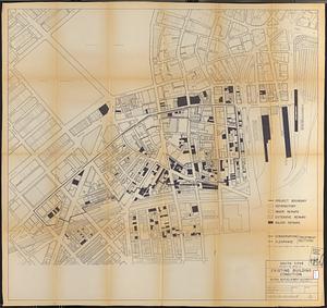
South Cove project no. Mass. r- : existing building condition
42.
Annexation map
43.
Atlas of the city of Boston : Boston proper : from actual surveys and official plans
44.
Atlas of the city of Boston : Boston proper and Back Bay : from actual surveys and official plans
45.
Atlas of the city of Boston : Boston proper and Back Bay : from actual surveys and official plans
46.
Atlas of the city of Boston : Boston proper and Back Bay : from actual surveys and official plans
47.
Atlas of the city of Boston : Boston proper and Back Bay : from actual surveys and official plans
48.
Atlas of the city of Boston : Boston proper and Back Bay : from actual surveys and official plans
49.
Atlas of the city of Boston : Boston proper and Back Bay : from actual surveys and official plans
50.
Atlas of the city of Boston : Boston proper and Back Bay : from actual surveys and official plans
51.
Atlas of the city of Boston : Boston proper and Roxbury : from actual surveys and official plans
52.
Atlas of the city of Boston : city proper : volume 1 : from actual surveys and official records
53.
Atlas of the city of Boston : city proper and Roxbury : from actual surveys and official plans
54.
Atlas of the city of Boston : city proper, volume one : from actual surveys and official plans
55.
Atlas of the city of Boston : city proper, volume two : from actual surveys and official plans
56.
Atlas of the city of Boston : Roxbury : from actual surveys and official plans
57.
Atlas of the county of Suffolk, Massachusetts : vol. 1st including Boston proper : from actual surveys and official records
58.
Ausicht von Boston : nach der natur aufgenommen
59.
Back Bay and Parker Hill parks : Parker Hill and Jamaica parkways : Boston and Roxbury districts
60.
Bartlett's illustrated map of Boston, or, Stranger's guide showing the public buildings, places of amusement & its'...
‹ Prev
Next ›
1
2
3
4
5
6
7
…
443
444