Toggle navigation
LMEC Home
Exhibitions
Georeferencing
Tools for Teachers
Collections
My Favorites
Sign Up / Log In
Search
Search the map portal
Map Collection
Map Collection
Map Sets
Search
Search
Search for
Search In
All Fields
Creator
Title
Subject
Place
Search All Digital Collections
Advanced Search
8885 Results
My Search
Start Over
More Like
commonwealth:wd376722h
Remove constraint More Like: commonwealth:wd376722h
Filter your Search
Place
North and Central America
6,116
United States
5,032
Massachusetts
2,136
Europe
1,396
Suffolk (county)
1,207
Boston
1,180
Canada
456
Asia
438
more
Place
»
Topic
Boston (Mass.)--Maps
752
United States--Maps
282
Real property--Massachusetts--Boston--Maps
195
Massachusetts--Maps
168
City planning--Massachusetts--Boston--Maps
157
Landowners--Massachusetts--Boston--Maps
142
New England--Maps
127
North America--Maps--Early works to 1800
103
more
Topic
»
Date
Date range begin
–
Date range end
Current results range from
1482
to
2023
View distribution
Creator
United States. Hydrographic Office
595
Boston Redevelopment Authority
162
O.H. Bailey & Co
148
Des Barres, Joseph F. W. (Joseph Frederick Wallet), 1722-1824
124
United States. Post Office Dept
120
Ptolemy, 2nd cent
100
Walling, Henry Francis, 1825-1888
94
Geological Survey (U.S.)
87
more
Creator
»
Format
Maps/Atlases
8,825
Manuscripts
215
Prints
56
Books
36
Objects/Artifacts
10
Drawings/Illustrations
8
Posters
5
Georeferenced
Yes
885
No
8,000
Collection
Norman B. Leventhal Map & Education Center Collection
8,727
Boston and New England Maps
2,363
Urban Maps
2,142
Maritime Charts and Atlases
1,083
American Revolutionary War-Era Maps
653
Boston Redevelopment Authority Collection
191
Mapping Boston Collection
20
Maps from AAS
16
more
Collection
»
Available to use
No known restrictions
8,668
Creative Commons license
73
Search Constraints
Sort by relevance
relevance
title
date (asc)
date (desc)
Number of results to display per page
20 per page
10
per page
20
per page
50
per page
100
per page
View results as:
grid view
map view
Search Results
7341.
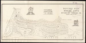
Revised plan of house lots belonging to the Duxbury Shore Co : Duxbury, Mass., July 1871
7342.
Rhein Panorama von Cöln nach Düsseldorf und Mainz
7343.
Rhemi : Partie meridionale du dioecese, et archevesché de Rheims en Champagne : la ou sont les Duché, et pairrie partie du...
7344.
Rhemi : partie septentrle du Dioecse et Archevesché de Rheims en Champagne : la ou sont les Bailiage, Duche, et Eslection de...
7345.
Rhenolandiae et Amstellandiae exactissima tabula
7346.
Rhode Island
7347.
Rhode Island
7348.
Rhode Island
7349.
Richard Mayer's commercial map of Northern Chili, Bolivia & southern Peru
7350.
Richard Mayer's commercial map of the republic of Paraguay
7351.
Richard Mayer's commercial of the Republic of Costa Rica
7352.
Richards standard atlas of Hampden County, Massachusetts : based upon, and carefully compiled from, the official plans, surveys...
7353.
Richards standard atlas of the city of Holyoke, Massachusetts : containing ten double page maps in colors, covering the entire...
7354.
Richards standard atlas of the city of Lynn and the towns of Swampscott, Saugus and Nahant, Massachusetts : from official...
7355.
Richards standard atlas of the city of Springfield and the town of Longmeadow, Massachusetts
7356.
Richards standard atlas of the city of Springfield and the town of Longmeadow, Massachusetts [plate 1]
7357.
Richards standard atlas of the city of Springfield and the town of Longmeadow, Massachusetts [plate 10]
7358.
Richards standard atlas of the city of Springfield and the town of Longmeadow, Massachusetts [plate 9]
7359.
Richards standard atlas of the City of Worcester Massachusetts : containing thirty-one double page maps in colors, covering the...
7360.
Richards standard atlas of the City of Worcester Massachusetts : containing thirty-one double page maps in colors, covering the...
‹ Prev
Next ›
1
2
…
364
365
366
367
368
369
370
371
372
…
444
445


![Richards standard atlas of the city of Springfield and the town of Longmeadow, Massachusetts [plate 1]](https://bpldcassets.blob.core.windows.net/derivatives/images/commonwealth:3f463814r/image_thumbnail_300.jpg)
![Richards standard atlas of the city of Springfield and the town of Longmeadow, Massachusetts [plate 10]](https://bpldcassets.blob.core.windows.net/derivatives/images/commonwealth:3f463818v/image_thumbnail_300.jpg)
![Richards standard atlas of the city of Springfield and the town of Longmeadow, Massachusetts [plate 9]](https://bpldcassets.blob.core.windows.net/derivatives/images/commonwealth:3f4638169/image_thumbnail_300.jpg)