Toggle navigation
LMEC Home
Exhibitions
Georeferencing
Tools for Teachers
Collections
My Favorites
Sign Up / Log In
Search
Search the map portal
Map Collection
Map Collection
Map Sets
Search
Search
Search for
Search In
All Fields
Creator
Title
Subject
Place
Search All Digital Collections
Advanced Search
8698 Results
My Search
Start Over
More Like
commonwealth:wd3766963
Remove constraint More Like: commonwealth:wd3766963
Filter your Search
Place
North and Central America
5,929
United States
4,846
Massachusetts
2,080
Europe
1,396
Suffolk (county)
1,046
Boston
1,019
Canada
449
Asia
438
more
Place
»
Topic
Boston (Mass.)--Maps
587
United States--Maps
282
Real property--Massachusetts--Boston--Maps
175
Massachusetts--Maps
163
Landowners--Massachusetts--Boston--Maps
133
North America--Maps--Early works to 1800
103
New England--Maps
102
Europe--Maps
79
more
Topic
»
Date
Date range begin
–
Date range end
Current results range from
1482
to
2023
View distribution
Creator
United States. Hydrographic Office
595
O.H. Bailey & Co
148
Des Barres, Joseph F. W. (Joseph Frederick Wallet), 1722-1824
123
United States. Post Office Dept
120
Ptolemy, 2nd cent
100
Walling, Henry Francis, 1825-1888
94
Geological Survey (U.S.)
86
Jefferys, Thomas, -1771
85
more
Creator
»
Format
Maps/Atlases
8,638
Manuscripts
215
Prints
56
Books
36
Objects/Artifacts
10
Drawings/Illustrations
8
Posters
5
Georeferenced
Yes
869
No
7,829
Collection
Norman B. Leventhal Map & Education Center Collection
8,694
Boston and New England Maps
2,232
Urban Maps
2,023
Maritime Charts and Atlases
1,083
American Revolutionary War-Era Maps
616
Boston Redevelopment Authority Collection
87
Massachusetts Real Estate Atlases
3
Sidney R. Knafel Map Collection at Phillips Academy
1
Available to use
No known restrictions
8,552
Creative Commons license
47
Search Constraints
Sort by relevance
relevance
title
date (asc)
date (desc)
Number of results to display per page
20 per page
10
per page
20
per page
50
per page
100
per page
View results as:
grid view
map view
Search Results
1.
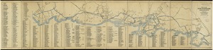
Chart of the harbours of Salem, Marblehead, Beverly and Manchester : from a survey taken in the years 1804, 5 & 6
2.
Chart of the harbours of Salem, Marblehead, Beverly, and Manchester : from a survey taken in the years 1804, 5 & 6
3.
Historic Massachusetts : a travel map to help you feel at home in the Bay State
4.
Map of the Beverly and Manchester shore Massachusetts
5.
Atlas of Middlesex County : volume 1, Cambridge, Somerville, Arlington, Belmont, Watertown, Everett, Malden, Medford, Newton,...
6.
Atlas of Middlesex County : volume 2, cities of Melrose & Woburn, towns of Bedford, Burlington, Concord, North Reading,...
7.
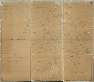
Atlas of Middlesex County, Massachusetts : compiled from recent and actual surveys and records
8.
Atlas of Middlesex County, Massachusetts, volume 3 : towns of Ashland, Framingham, Holliston, Hopkinton, Natick, Sherborn,...
9.
Atlas of the towns of Watertown, Belmont, Arlington and Lexington, Middlesex County, Mass. : from official plans and actual...
10.
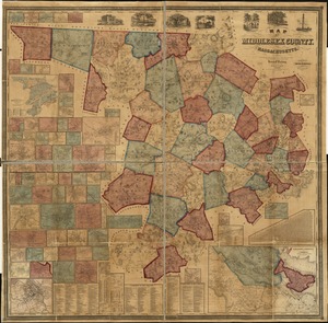
County atlas of Middlesex, Massachusetts : from actual surveys
11.
Map of Middlesex County, Mass : copied from a map belonging to the state, with various additions and alterations, by order of...
12.
Map of Middlesex County, Massachusetts : based upon the trigonometrical survey of the state
13.
Map of parts of Middlesex & Essex counties, showing the rail road routes between Salem, Lowell, Boston & Methuen
14.
Map of the water region of the county of Middlesex exhibiting the mode of supplying Boston & Charlestown with soft water from...
15.
Plan of Middlesex County, Massachusetts
16.
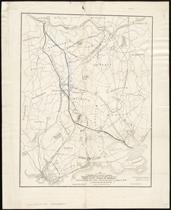
[Boston and Northwestern Junction Railroad]
17.
Diagram of rail roads diverging from Boston : showing the depots and distances
18.
Dinsmore's new railroad map of the United States and the Canadas, showing all the railroads completed and in progress,...
19.
Hale's map of the central & western parts of Massachusetts, with a part of New-York
20.
Map of Baldwinville and Winchendon rail road routes
‹ Prev
Next ›
1
2
3
4
5
…
434
435


![[Boston and Northwestern Junction Railroad]](https://bpldcassets.blob.core.windows.net/derivatives/images/commonwealth:x059cc74n/image_thumbnail_300.jpg)


