Toggle navigation
LMEC Home
Exhibitions
Georeferencing
Tools for Teachers
Collections
My Favorites
Sign Up / Log In
Search
Search the map portal
Map Collection
Map Collection
Map Sets
Search
Search
Search for
Search In
All Fields
Creator
Title
Subject
Place
Search All Digital Collections
Advanced Search
8555 Results
My Search
Start Over
More Like
commonwealth:wd3766165
Remove constraint More Like: commonwealth:wd3766165
Filter your Search
Place
North and Central America
5,850
United States
4,772
Massachusetts
2,056
Europe
1,359
Suffolk (county)
1,034
Boston
1,007
Canada
448
Asia
422
more
Place
»
Topic
Boston (Mass.)--Maps
579
United States--Maps
273
Real property--Massachusetts--Boston--Maps
174
Massachusetts--Maps
162
Landowners--Massachusetts--Boston--Maps
132
North America--Maps--Early works to 1800
103
New England--Maps
99
Europe--Maps
78
more
Topic
»
Date
Date range begin
–
Date range end
Current results range from
1482
to
2023
View distribution
Creator
United States. Hydrographic Office
594
O.H. Bailey & Co
148
Des Barres, Joseph F. W. (Joseph Frederick Wallet), 1722-1824
123
United States. Post Office Dept
120
Ptolemy, 2nd cent
100
Walling, Henry Francis, 1825-1888
93
Geological Survey (U.S.)
87
Jefferys, Thomas, -1771
85
more
Creator
»
Format
Maps/Atlases
8,496
Manuscripts
215
Prints
56
Books
36
Objects/Artifacts
10
Drawings/Illustrations
8
Posters
4
Georeferenced
Yes
869
No
7,686
Collection
Norman B. Leventhal Map & Education Center Collection
8,551
Boston and New England Maps
2,205
Urban Maps
1,936
Maritime Charts and Atlases
1,081
American Revolutionary War-Era Maps
617
Boston Redevelopment Authority Collection
87
Massachusetts Real Estate Atlases
3
Applied Geographics, Inc. Records
1
more
Collection
»
Available to use
No known restrictions
8,410
Creative Commons license
46
Search Constraints
Sort by relevance
relevance
title
date (asc)
date (desc)
Number of results to display per page
20 per page
10
per page
20
per page
50
per page
100
per page
View results as:
grid view
map view
Search Results
3301.
Map of Atlantic & Pacific Rail Road
3302.
Map of Augusta County, Virginia
3303.
Map of Australia, compiled from the nautical surveys, made by order of The Admiralty and other authentic documents
3304.
Map of Baldwinville and Winchendon rail road routes
3305.
Map of Bar Harbor, Maine
3306.
Map of Bath, Maine
3307.
Map of battles on Bull Run, near Manassas, on the line of Fairfax & Prince William Counties, in Virginia, fought between the...
3308.
Map of Bennington County, Vermont
3309.
[Map of Berkshire County]
3310.
A map of Berkshire County Mass
3311.
Map of Beverly
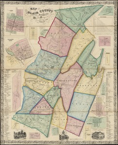
3312.
Map of Blair County, Pennsylvania : from special surveys
3313.
Map of Bohemia, Pensacola Bay, Florida
3314.
Map of Boston
3315.
Map of Boston : from the latest surveys
3316.
Map of Boston
3317.
Map of Boston : showing health districts and undrained and filled land
3318.
Map of Boston
3319.
Map of Boston : engraved expressly for Clark's Boston blue book
3320.
Map of Boston
‹ Prev
Next ›
1
2
…
162
163
164
165
166
167
168
169
170
…
427
428


![[Map of Berkshire County]](https://bpldcassets.blob.core.windows.net/derivatives/images/commonwealth:wd376641h/image_thumbnail_300.jpg)