Toggle navigation
LMEC Home
Exhibitions
Georeferencing
Tools for Teachers
Collections
My Favorites
Sign Up / Log In
Search
Search the map portal
Map Collection
Map Collection
Map Sets
Search
Search
Search for
Search In
All Fields
Creator
Title
Subject
Place
Search All Digital Collections
Advanced Search
9053 Results
My Search
Start Over
More Like
commonwealth:td96nk45j
Remove constraint More Like: commonwealth:td96nk45j
Filter your Search
Place
North and Central America
6,284
United States
5,202
Massachusetts
2,156
Suffolk (county)
1,404
Europe
1,396
Boston
1,377
Canada
449
Asia
438
more
Place
»
Topic
Boston (Mass.)--Maps
677
City planning--Massachusetts--Boston--Maps
418
United States--Maps
282
Urban renewal--Massachusetts--Boston--Maps
253
Real property--Massachusetts--Boston--Maps
217
Massachusetts--Maps
162
Landowners--Massachusetts--Boston--Maps
136
North America--Maps--Early works to 1800
103
more
Topic
»
Date
Date range begin
–
Date range end
Current results range from
1482
to
2023
View distribution
Creator
United States. Hydrographic Office
595
Boston Redevelopment Authority
391
O.H. Bailey & Co
148
Des Barres, Joseph F. W. (Joseph Frederick Wallet), 1722-1824
123
United States. Post Office Dept
120
Ptolemy, 2nd cent
100
Walling, Henry Francis, 1825-1888
94
Geological Survey (U.S.)
86
more
Creator
»
Format
Maps/Atlases
8,992
Manuscripts
215
Prints
56
Books
36
Objects/Artifacts
10
Drawings/Illustrations
9
Posters
5
Georeferenced
Yes
870
No
8,183
Collection
Norman B. Leventhal Map & Education Center Collection
8,696
Boston and New England Maps
2,587
Urban Maps
2,374
Maritime Charts and Atlases
1,083
American Revolutionary War-Era Maps
620
Boston Redevelopment Authority Collection
439
William L. Clements Library Collection
3
Mapping Boston Collection
2
more
Collection
»
Available to use
No known restrictions
8,905
Creative Commons license
49
Search Constraints
Sort by relevance
relevance
title
date (asc)
date (desc)
Number of results to display per page
20 per page
10
per page
20
per page
50
per page
100
per page
View results as:
grid view
map view
Search Results
181.
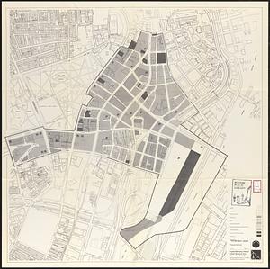
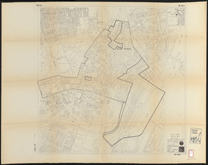
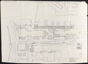
Central business district urban renewal area Massachusetts r-82 : proposed land use
182.
Central business district urban renewal area Massachusetts r-82 : property map
183.
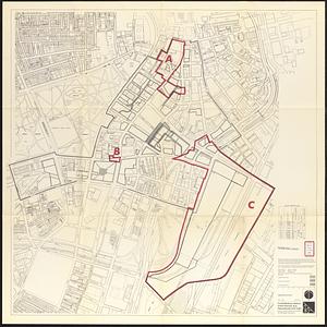
Central business district urban renewal area Massachusetts r-82 A,B,C : disposition parcels
184.
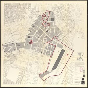
Central business district urban renewal area Massachusetts r-82 A,B,C : proposed land use
185.
Central business district urban renewal area Massachusetts r-82 A,B,C : zoning
186.
Central business district urban renewal area R-82 : sub area boundaries
187.
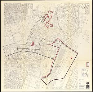
Central business district urban renewal area r-82 : parcel acquisition map
188.
Central business district urban renewal area r-82 : existing land use
189.
Central business district urban renewal area r-82 : building deficiencies
190.
Charlestown renewal area : location map
191.
Charlestown renewal area : blighted areas
192.
City of Boston topographic and planimetric survey
193.
Columbia Point feasibility survey area
194.
Conceptual plan
195.
Conceptual plan
196.
Copley Square : layout and pavement plan with tree numbers added
197.
Cultural facilities conceptual plan
198.
DEM/BRA Long Wharf master plan : schematic'
199.
Developer's kit : South Cove urban renewal area, project no. Mass. r-92, parcel r-7, residential use
200.
Development of the Calfpasture, Boston, Massachusetts
‹ Prev
Next ›
1
2
…
6
7
8
9
10
11
12
13
14
…
452
453