Toggle navigation
LMEC Home
Exhibitions
Georeferencing
Tools for Teachers
Collections
My Favorites
Sign Up / Log In
Search
Search the map portal
Map Collection
Map Collection
Map Sets
Search
Search
Search for
Search In
All Fields
Creator
Title
Subject
Place
Search All Digital Collections
Advanced Search
8704 Results
My Search
Start Over
More Like
commonwealth:q524n375s
Remove constraint More Like: commonwealth:q524n375s
Filter your Search
Place
North and Central America
5,935
United States
4,853
Massachusetts
2,079
Europe
1,396
Suffolk (county)
1,047
Boston
1,020
Canada
449
Asia
438
more
Place
»
Topic
Boston (Mass.)--Maps
587
United States--Maps
282
Real property--Massachusetts--Boston--Maps
175
Massachusetts--Maps
162
Landowners--Massachusetts--Boston--Maps
133
North America--Maps--Early works to 1800
103
New England--Maps
102
Europe--Maps
79
more
Topic
»
Date
Date range begin
–
Date range end
Current results range from
1482
to
2023
View distribution
Creator
United States. Hydrographic Office
595
O.H. Bailey & Co
148
Des Barres, Joseph F. W. (Joseph Frederick Wallet), 1722-1824
123
United States. Post Office Dept
120
Ptolemy, 2nd cent
100
Walling, Henry Francis, 1825-1888
94
Geological Survey (U.S.)
86
Jefferys, Thomas, -1771
86
more
Creator
»
Format
Maps/Atlases
8,644
Manuscripts
215
Prints
56
Books
36
Objects/Artifacts
10
Drawings/Illustrations
8
Posters
5
Georeferenced
Yes
869
No
7,835
Collection
Norman B. Leventhal Map & Education Center Collection
8,694
Boston and New England Maps
2,234
Urban Maps
2,024
Maritime Charts and Atlases
1,083
American Revolutionary War-Era Maps
625
Boston Redevelopment Authority Collection
88
MacLean Collection Map Library
6
William L. Clements Library Collection
3
Available to use
No known restrictions
8,553
Creative Commons license
47
Search Constraints
Sort by relevance
relevance
title
date (asc)
date (desc)
Number of results to display per page
20 per page
10
per page
20
per page
50
per page
100
per page
View results as:
grid view
map view
Search Results
1.
Map of the seat of war : containing a map of the vicinity of Washington, Baltimore, Harper's Ferry and Annapolis, with five...
2.
Colton's Georgetown and the city of Washington : the capital of the United States of America ; Colton's map showing part of...
3.
Kaart van Nieuw Nederland : behoorende tot de door het Provinciaal Utrechtsch genootschap bekroonde verhandeling
4.
The Keystone group : a new railroad, post-office, township and district map of Pennsylvania, New Jersey, Delaware, Maryland,...
5.
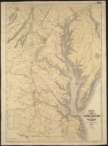
Map of part of Virginia, Maryland and Delaware from the best authorities
6.
Map of the Boston and Northwestern, Massachusetts Central, and Boston and Poughkeepsie Railroads and their connections
7.
Map of the country embracing the several routes examined with a view to a national road from Washington to Lake Ontario
8.
Map of the eastern and middle states
9.
Map of the New England and Middle Atlantic States
10.
Map of the South Mountain and Boston Railroad & connections showing territory passed through, rail-roads and canals crossed or...
11.
Map of the State of New York with part of the states of Pennsylvania, New Jersey &c
12.
Map of Virginia and West Va., North and part of South Carolina, Maryland and Delaware, showing the situation in these states of...
13.
Map second division railway mail service
14.
Map showing the lines of canals & rail roads owned, leased & operated by the Delaware and Hudson Canal and Rail Road Co. with...
15.
The new war map of Virginia, Maryland & Pennsylvania
16.
Seagram's vacation map of the east
17.
A survey of the empire group : with a complete distance table, a compendious index of cities and post offices, with populations...
18.
A survey of the empire group : with a complete distance table, a compendious index of cities and post offices, with populations...
19.
Vereinigte Staaten von Nord-Amerika in 6 blattern, bl. 3
20.
19th annual convention of the National Association of Real Estate Boards : at Tulsa, June 7 to June 11 in 1926
‹ Prev
Next ›
1
2
3
4
5
…
435
436