Toggle navigation
LMEC Home
Exhibitions
Georeferencing
Tools for Teachers
Collections
My Favorites
Sign Up / Log In
Search
Search the map portal
Map Collection
Map Collection
Map Sets
Search
Search
Search for
Search In
All Fields
Creator
Title
Subject
Place
Search All Digital Collections
Advanced Search
370 Results
My Search
Start Over
More Like
commonwealth:q524mv470
Remove constraint More Like: commonwealth:q524mv470
Filter your Search
Place
North and Central America
303
United States
232
Pennsylvania
40
New York
37
Virginia
37
Canada
31
North America
31
Suffolk (county)
31
more
Place
»
Topic
Virginia--Maps--Early works to 1800
38
Pennsylvania--Maps--Early works to 1800
37
North America--Maps--Early works to 1800
23
Maryland--Maps--Early works to 1800
22
United States--History--French and Indian War, 1754-1763--Maps--Early works to 1800
17
Boston (Mass.)--History--Revolution, 1775-1783--Maps--Early works to 1800
16
New Jersey--Maps--Early works to 1800
12
Middle Atlantic States--Maps--Early works to 1800
10
more
Topic
»
Date
Date range begin
–
Date range end
Current results range from
1590
to
1799
View distribution
Creator
Jefferys, Thomas, -1771
37
Faden, William, 1749-1836
34
Sayer, Robert, 1725-1794
24
Le Rouge, Georges-Louis
23
Des Barres, Joseph F. W. (Joseph Frederick Wallet), 1722-1824
22
Korn, Christoph Heinrich, 1726-1783
11
Raspe, Gabriel Nicolaus, 1712-1785
11
Robert Sayer and John Bennett (Firm)
10
more
Creator
»
Format
Maps/Atlases
327
Prints
32
Manuscripts
25
Drawings/Illustrations
9
Books
2
Georeferenced
Yes
16
No
354
Collection
American Revolutionary War-Era Maps
352
Richard H. Brown Revolutionary War Map Collection at Mount Vernon
293
Norman B. Leventhal Map & Education Center Collection
42
MacLean Collection Map Library
18
New York Public Library Collection
8
Maritime Charts and Atlases
5
Boston and New England Maps
4
British Library Collection
3
more
Collection
»
Available to use
Creative Commons license
306
No known restrictions
44
Search Constraints
Sort by relevance
relevance
title
date (asc)
date (desc)
Number of results to display per page
20 per page
10
per page
20
per page
50
per page
100
per page
View results as:
grid view
map view
Search Results
321.
The seat of action, between the British and American forces : or an authentic plan of the western part of Long Island, with the...
322.
The seat of war in New England, by an American volunteer : with the marches of the several corps sent by the Colonies towards...
323.
Sketch of part of the island of Ste. Lucie : computed at about 2500 feet to 1 inch
324.
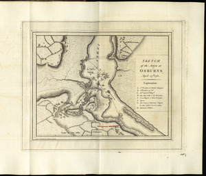
Sketch of the action at Osburns, April 27th. 1781
325.
A sketch of the action between the British forces and the American provincials, on the heights of the peninsula of Charlestown,...
326.
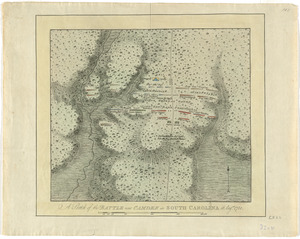
A sketch of the battle near Camden in South Carolina, 16 Augst. 1780
327.
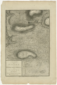
Sketch of the battle of Hobkirks Hill, near Camden, on the 25th April 1781
328.
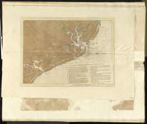
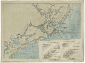
A sketch of the environs of Charlestown in South Carolina
329.
A sketch of the environs of Charlestown in South Carolina
330.
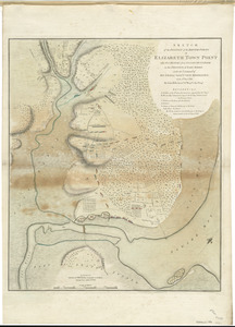
Sketch of the position of the British forces at Elizabeth Town Point after their return from Connecticut Farm, in the province...
331.
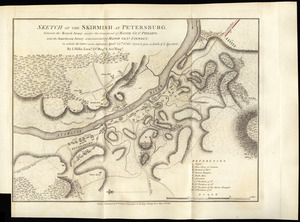
Sketch of the skirmish at Petersburg, between the Royal Army under the command of Major Genl. Phillips, and the American Army...
332.
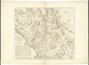
Sketch of the surprise of German Town by the American forces commanded by General Washington October 4th 1777
333.
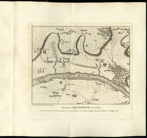
Skirmish at Richmond Jan. 5th. 1781
334.
A south east view of the city of New York, in North America = Vue de sud est de la ville de New York, dans l'Amerique...
335.
A south west view of the city of New York, in North America = Vue de sud ouest de la ville de New York, dans l'Amerique...
336.
Ste. Lucie : d'après les plans levés par les Anglois lors qu'ils le possedoient
337.
Suite du theatre de la guerre dans l'Amérique Septentrionale y compris le Golfe du Méxique
338.
Surprize of rebels at Hancock's House
339.
Tabago
340.
Der Teufels Belt gemeiniglich genannt der Lange Insels Sund
‹ Prev
Next ›
1
2
…
13
14
15
16
17
18
19