Toggle navigation
LMEC Home
Exhibitions
Georeferencing
Tools for Teachers
Collections
My Favorites
Sign Up / Log In
Search
Search the map portal
Map Collection
Map Collection
Map Sets
Search
Search
Search for
Search In
All Fields
Creator
Title
Subject
Place
Search All Digital Collections
Advanced Search
307 Results
My Search
Start Over
More Like
commonwealth:q524mv24p
Remove constraint More Like: commonwealth:q524mv24p
Filter your Search
Place
North and Central America
232
United States
165
Canada
36
New York
31
Suffolk (county)
31
Boston
29
North America
27
Charleston (county)
10
more
Place
»
Topic
North America--Maps--Early works to 1800
18
Boston (Mass.)--History--Revolution, 1775-1783--Maps--Early works to 1800
16
Vues d'optique
10
Coasts--Newfoundland and Labrador--Maps--Early works to 1800
9
Gibraltar--History--Siege, 1779-1783--Maps--Early works to 1800
9
New York (N.Y.)--Pictorial works--Early works to 1800
9
United States--History--French and Indian War, 1754-1763--Maps--Early works to 1800
9
United States--Maps--Early works to 1800
9
more
Topic
»
Date
Date range begin
–
Date range end
Current results range from
1647
to
1816
View distribution
Creator
Faden, William, 1749-1836
33
Jefferys, Thomas, -1771
29
Des Barres, Joseph F. W. (Joseph Frederick Wallet), 1722-1824
23
Le Rouge, Georges-Louis
23
Sayer, Robert, 1725-1794
19
Korn, Christoph Heinrich, 1726-1783
11
Raspe, Gabriel Nicolaus, 1712-1785
11
Simcoe, John Graves, 1752-1806
10
more
Creator
»
Format
Maps/Atlases
264
Prints
32
Manuscripts
23
Drawings/Illustrations
9
Books
2
Georeferenced
Yes
12
No
295
Collection
American Revolutionary War-Era Maps
294
Richard H. Brown Revolutionary War Map Collection at Mount Vernon
293
Maritime Charts and Atlases
13
Norman B. Leventhal Map Center Collection
13
Boston and New England Maps
4
Urban Maps
2
Boston Athenaeum, Cartographic Collection
1
Available to use
Creative Commons license
294
No known restrictions
13
Search Constraints
Sort by relevance
relevance
title
date (asc)
date (desc)
Number of results to display per page
20 per page
10
per page
20
per page
50
per page
100
per page
View results as:
grid view
map view
Search Results
1.
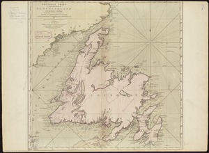
A chart of the banks and part of the coast of Newfoundland including the islands of Sable and Cape Breton
2.
A chart of the banks and part of the coast of Newfoundland including the islands of Sable and Cape Breton
3.
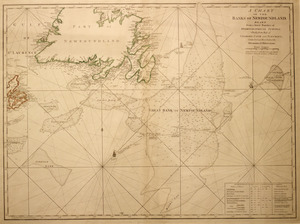
A chart of the Banks of Newfoundland, drawn from a great number of hydrographical surveys, chiefly from those of Chabert, Cook...
4.
The coast of New Schotland, New England, the gulph and river of St. Laurence : the islands of New Foundland, Cape Breton, St....
5.
A general chart of the island of Newfoundland with the rocks & soundings
6.
Canada orientale nell' America Settentrionale
7.
A chart of the Banks of Newfoundland
8.
A chart of the Banks of Newfoundland
9.
Chart of the banks of Newfoundland, drawn from a great number of hydrographical surveys, these charts are followed, according...
10.
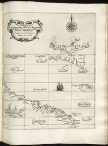
Carta particolare della Meta Incognita Australe con una parte della America Settentrionale
11.
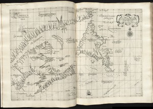
Carta particolare della terra nuoua con la Gran Baia et il Fiume Grande della Canida
12.
A chart of the Streights of Bell Isle
13.
Chart of the Streights of Belle Isle
14.
Chart of the streights of Belle Isle
15.
Chart of the streights of Belle Isle
16.
[A map of part of Pennsylvania & Maryland intended to shew, at one view, the several places proposed for opening a...
17.
Abriss der stadt Gibraltar und der darinn befindlichen festen platze, nebst dem meerbusen von Algesiras
18.
An accurate map of His Majesty's province of New-Hampshire in New England : taken from actual surveys of all the inhabited...
19.
An accurate map of Staten Island : with that part of New York, Long Island and the Jerseys, which is the rendesvous of the two...
20.
An accurate map of the country round Boston in New England from the best authorities
‹ Prev
Next ›
1
2
3
4
5
…
15
16


![[A map of part of Pennsylvania & Maryland intended to shew, at one view, the several places proposed for opening a communication between the waters of the Delaware & Chesopeak Bays]](https://bpldcassets.blob.core.windows.net/derivatives/images/commonwealth:z603vt12v/image_thumbnail_300.jpg)


