Toggle navigation
LMEC Home
Exhibitions
Georeferencing
Tools for Teachers
Collections
My Favorites
Sign Up / Log In
Search
Search the map portal
Map Collection
Map Collection
Map Sets
Search
Search
Search for
Search In
All Fields
Creator
Title
Subject
Place
Search All Digital Collections
Advanced Search
797 Results
My Search
Start Over
More Like
commonwealth:pr76mn66w
Remove constraint More Like: commonwealth:pr76mn66w
Filter your Search
Place
North and Central America
713
United States
516
North America
148
New York
105
Canada
79
New Jersey
57
South Carolina
40
Virginia
36
more
Place
»
Topic
United States--History--Revolution, 1775-1783--Maps
330
North America--Maps
85
North America--Maps--Early works to 1800
60
United States--Maps--Early works to 1800
44
Canada--Maps--Early works to 1800
38
Newport (R.I.)--Maps
24
United States--Maps
21
Charleston (S.C.)--Maps
17
more
Topic
»
Date
Date range begin
–
Date range end
Current results range from
1623
to
1999
View distribution
Creator
Faden, William, 1749-1836
23
Robert Sayer and John Bennett (Firm)
19
Jefferys, Thomas, -1771
18
Clinton, Henry, Sir, 1738?-1795
17
Gibson, J. (John), active 1750-1792
17
Bellin, Jacques Nicolas, 1703-1772
16
Anville, Jean Baptiste Bourguignon d', 1697-1782
15
Hills, John, active 1777-1819
14
more
Creator
»
Format
Maps/Atlases
790
Manuscripts
7
Drawings/Illustrations
5
Paintings
3
Ephemera
1
Objects/Artifacts
1
Prints
1
Georeferenced
Yes
15
No
782
Collection
American Revolutionary War-Era Maps
698
MacLean Collection Map Library
379
William L. Clements Library Collection
321
Norman B. Leventhal Map & Education Center Collection
51
American Antiquarian Society Collection
24
New York Public Library Collection
10
Boston and New England Maps
5
Richard H. Brown Revolutionary War Map Collection at Mount Vernon
4
more
Collection
»
Available to use
No known restrictions
54
Creative Commons license
16
Search Constraints
Sort by relevance
relevance
title
date (asc)
date (desc)
Number of results to display per page
20 per page
10
per page
20
per page
50
per page
100
per page
View results as:
grid view
map view
Search Results
401.
The theatre of war in North America, with the roads and a table of the distances
402.
Thirty-miles round Boston
403.
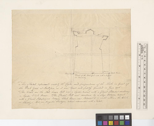
This sketch represents nearly the figure and proportions of the work in front of the dock yard at Hallifax as it was traced and...
404.
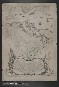
To his e[xcellency] G. Washington commander in chief of the armies of the United States of America this plan of the investment...
405.
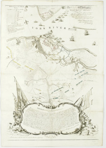
To his excellency General Washington, commander in chief of the armies of the United States of America : this plan of the...
406.
To His Excellency Genl. Washington, Commander in Chief of the armies of the United States of America : this plan of the...
407.
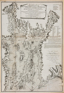
A topographical chart of the bay of Narraganset in the province of New England, with all the isles contained therein, among...
408.
The United States of America laid down from the best authorities, agreeable to the peace of 1783
409.
Valley of the Hudson River from Fishkill to Teller's Point
410.
Verplanks
411.
Verplanks Point
412.
View from the blockhouse : Dorchester Neck
413.
View of Dorchester Neck from Enoch Brown's
414.
View of Dorchester Neck, from the mess house on Fort Hill
415.
View of Dorchester Neck, from the mess house on Fort Hill
416.
A view of the Great Bridge near Norfolk in Virginia where the action happened between a detachment of the 14th Regt: & a body...
417.
Washingtons position at Morristown 1780 : headquarters at Fords house
418.
West Point
419.
West Point and the Hudson River
420.
West Point and vicinity
‹ Prev
Next ›
1
2
…
17
18
19
20
21
22
23
24
25
…
39
40


![To his e[xcellency] G. Washington commander in chief of the armies of the United States of America this plan of the investment of York and Goucester [sic] has been surveyed and laid down, and is most humbly dedicated](https://bpldcassets.blob.core.windows.net/derivatives/metadata/commonwealth-oai:9g552g940/image_thumbnail_300.jpg)