Toggle navigation
LMEC Home
Exhibitions
Georeferencing
Tools for Teachers
Collections
My Favorites
Sign Up / Log In
Search
Search the map portal
Map Collection
Map Collection
Map Sets
Search
Search
Search for
Search In
All Fields
Creator
Title
Subject
Place
Search All Digital Collections
Advanced Search
411 Results
My Search
Start Over
More Like
commonwealth:p8418t55q
Remove constraint More Like: commonwealth:p8418t55q
Filter your Search
Place
North and Central America
404
United States
362
New York
91
Virginia
68
New Jersey
52
York (county)
32
Yorktown
32
South Carolina
30
more
Place
»
Topic
United States--History--Revolution, 1775-1783--Maps
330
Virginia--Maps--Early works to 1800
38
Newport (R.I.)--Maps
24
Yorktown (Va.)--History--Siege, 1781--Maps--Early works to 1800
19
Maryland--Maps--Early works to 1800
17
Charleston (S.C.)--Maps
16
Hudson River (N.Y. and N.J.)--Maps
15
New Jersey--Maps
14
more
Topic
»
Date
Date range begin
–
Date range end
Current results range from
1590
to
1881
View distribution
Creator
Clinton, Henry, Sir, 1738?-1795
17
Hills, John, active 1777-1819
13
Faden, William, 1749-1836
12
André, John, 1751-1780
11
Montrésor, John, 1736-1799
10
Fage, Edward
9
Castries, Charles Eugène Gabriel de La Croix, marquis de, 1727-1801
8
D'Ethy, captain
8
more
Creator
»
Format
Maps/Atlases
405
Manuscripts
18
Drawings/Illustrations
5
Prints
1
Georeferenced
Yes
6
No
405
Collection
American Revolutionary War-Era Maps
389
William L. Clements Library Collection
305
Norman B. Leventhal Map & Education Center Collection
31
New-York Historical Society Collection
24
Richard H. Brown Revolutionary War Map Collection at Mount Vernon
14
MacLean Collection Map Library
9
American Antiquarian Society Collection
7
Boston and New England Maps
5
more
Collection
»
Available to use
No known restrictions
54
Creative Commons license
32
Search Constraints
Sort by relevance
relevance
title
date (asc)
date (desc)
Number of results to display per page
20 per page
10
per page
20
per page
50
per page
100
per page
View results as:
grid view
map view
Search Results
361.
Stony Point
362.
Sullivans Island
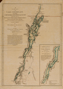
363.
A survey of Lake Champlain, including Lake George, Crown Point and St. John : surveyed by order of his excellency Major-General...
364.
A survey of the defile and that part of York Island adjacent to Fort Knyphausen
365.
A survey of the peninsula of Charles Town shewing the three posts now garrison'd by his majesty's troops for the winter : 10th...
366.
The theatre of war in North America, with the roads and a table of the distances
367.
Thirty-miles round Boston
368.
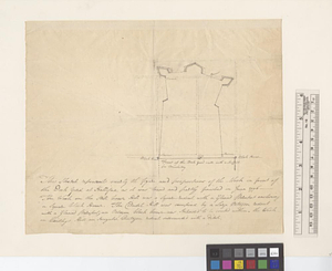
This sketch represents nearly the figure and proportions of the work in front of the dock yard at Hallifax as it was traced and...
369.
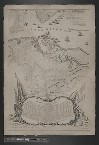
To his e[xcellency] G. Washington commander in chief of the armies of the United States of America this plan of the investment...
370.
To his excellency General Washington, commander in chief of the armies of the United States of America : this plan of the...
371.
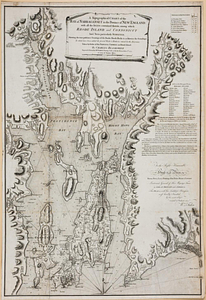
A topographical chart of the bay of Narraganset in the province of New England, with all the isles contained therein, among...
372.
The United States of America laid down from the best authorities, agreeable to the peace of 1783
373.
Valley of the Hudson River from Fishkill to Teller's Point
374.
Verplanks
375.
Verplanks Point
376.
View from the blockhouse : Dorchester Neck
377.
View of Dorchester Neck from Enoch Brown's
378.
View of Dorchester Neck, from the mess house on Fort Hill
379.
View of Dorchester Neck, from the mess house on Fort Hill
380.
A view of the Great Bridge near Norfolk in Virginia where the action happened between a detachment of the 14th Regt: & a body...
‹ Prev
Next ›
1
2
…
15
16
17
18
19
20
21


![To his e[xcellency] G. Washington commander in chief of the armies of the United States of America this plan of the investment of York and Goucester [sic] has been surveyed and laid down, and is most humbly dedicated](https://bpldcassets.blob.core.windows.net/derivatives/metadata/commonwealth-oai:9g552g940/image_thumbnail_300.jpg)