Toggle navigation
LMEC Home
Exhibitions
Georeferencing
Tools for Teachers
Collections
My Favorites
Sign Up / Log In
Search
Search the map portal
Map Collection
Map Collection
Map Sets
Search
Search
Search for
Search In
All Fields
Creator
Title
Subject
Place
Search All Digital Collections
Advanced Search
8803 Results
My Search
Start Over
More Like
commonwealth:cj82kt926
Remove constraint More Like: commonwealth:cj82kt926
Filter your Search
Place
North and Central America
6,034
United States
4,938
Massachusetts
2,155
Europe
1,396
Suffolk (county)
1,049
Boston
1,022
Canada
456
Asia
438
more
Place
»
Topic
Boston (Mass.)--Maps
592
United States--Maps
282
Massachusetts--Maps
235
Real property--Massachusetts--Boston--Maps
175
Landowners--Massachusetts--Boston--Maps
133
New England--Maps
127
North America--Maps--Early works to 1800
103
Europe--Maps
79
more
Topic
»
Date
Date range begin
–
Date range end
Current results range from
1482
to
2023
View distribution
Creator
United States. Hydrographic Office
595
O.H. Bailey & Co
148
Des Barres, Joseph F. W. (Joseph Frederick Wallet), 1722-1824
123
United States. Post Office Dept
120
Ptolemy, 2nd cent
100
Walling, Henry Francis, 1825-1888
95
Geological Survey (U.S.)
93
Jefferys, Thomas, -1771
86
more
Creator
»
Format
Maps/Atlases
8,742
Manuscripts
217
Prints
56
Books
36
Objects/Artifacts
10
Drawings/Illustrations
8
Posters
5
Ephemera
1
Georeferenced
Yes
882
No
7,921
Collection
Norman B. Leventhal Map & Education Center Collection
8,742
Boston and New England Maps
2,287
Urban Maps
2,024
Maritime Charts and Atlases
1,083
American Revolutionary War-Era Maps
660
Boston Redevelopment Authority Collection
90
David Judkins Weaver Papers
23
Applied Geographics, Inc. Records
20
more
Collection
»
Available to use
No known restrictions
8,600
Creative Commons license
54
Search Constraints
Sort by relevance
relevance
title
date (asc)
date (desc)
Number of results to display per page
20 per page
10
per page
20
per page
50
per page
100
per page
View results as:
grid view
map view
Search Results
1001.
Begin with sense, of ev'ry art the soul, parts answ'ring parts shall slide into a whole
1002.
The beginnings of ancient China, 1900-1300 B.C.
1003.
Behring's Sea and Arctic Ocean : from surveys of the U.S. North Pacific Surveying Expedition in 1855, Commander John Rodgers,...
1004.
Being a cartograph of Ohio : the oldest state west of the thirteen original colonies; now the fourth state in the Union in...
1005.
Being a map of the United States in the year 1831 when the Country Gentleman first made its appearance as the Genesee Farmer
1006.
Belgii veteris typus
1007.
Bellovaci et Silvanectes : les Eveschés de Beauvais et Senlis : Comté et Pairrie de Beauvais : Les Balliages de Beauvais,...
1008.
Bellows Falls, Vt
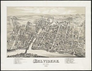
1009.
Belvidere : New Jersey
1010.
Belvidere Park : Lowell, Mass
1011.
Bennett's tourists' route map of Norway
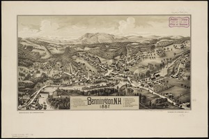
1012.
Bennington, N.H : 1887
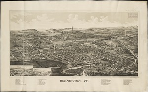
1013.
Bennington, Vt : [1887]
1014.
Berkeley Street community garden
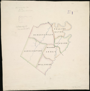
1015.
Berkley Co., W. Va
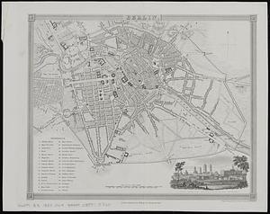
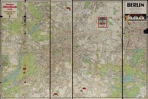
1016.
Berlin
1017.
Berlin Falls, N.H., and Berlin Mills : 1888
1018.
Berlin mit den 20 verwaltungsbezirken
1019.
Bermudas
1020.
The Bermudas, or Summer's Islands
‹ Prev
Next ›
1
2
…
47
48
49
50
51
52
53
54
55
…
440
441