Toggle navigation
LMEC Home
Exhibitions
Georeferencing
Tools for Teachers
Collections
My Favorites
Sign Up / Log In
Search
Search the map portal
Map Collection
Map Collection
Map Sets
Search
Search
Search for
Search In
All Fields
Creator
Title
Subject
Place
Search All Digital Collections
Advanced Search
8877 Results
My Search
Start Over
More Like
commonwealth:cj82kp336
Remove constraint More Like: commonwealth:cj82kp336
Filter your Search
Place
North and Central America
6,108
United States
5,024
Massachusetts
2,129
Europe
1,396
Suffolk (county)
1,210
Boston
1,181
Canada
449
Asia
438
more
Place
»
Topic
Boston (Mass.)--Maps
752
United States--Maps
282
Real property--Massachusetts--Boston--Maps
196
Massachusetts--Maps
166
City planning--Massachusetts--Boston--Maps
157
Landowners--Massachusetts--Boston--Maps
143
New England--Maps
104
North America--Maps--Early works to 1800
103
more
Topic
»
Date
Date range begin
–
Date range end
Current results range from
1482
to
2023
View distribution
Creator
United States. Hydrographic Office
595
Boston Redevelopment Authority
162
O.H. Bailey & Co
148
Des Barres, Joseph F. W. (Joseph Frederick Wallet), 1722-1824
124
United States. Post Office Dept
120
Ptolemy, 2nd cent
100
Walling, Henry Francis, 1825-1888
94
Geological Survey (U.S.)
87
more
Creator
»
Format
Maps/Atlases
8,817
Manuscripts
215
Prints
56
Books
36
Objects/Artifacts
10
Drawings/Illustrations
8
Posters
5
Georeferenced
Yes
885
No
7,992
Collection
Norman B. Leventhal Map & Education Center Collection
8,725
Boston and New England Maps
2,359
Urban Maps
2,143
Maritime Charts and Atlases
1,083
American Revolutionary War-Era Maps
638
Boston Redevelopment Authority Collection
191
Massachusetts Real Estate Atlases
26
Mapping Boston Collection
20
more
Collection
»
Available to use
No known restrictions
8,666
Creative Commons license
70
Search Constraints
Sort by relevance
relevance
title
date (asc)
date (desc)
Number of results to display per page
20 per page
10
per page
20
per page
50
per page
100
per page
View results as:
grid view
map view
Search Results
41.
Atlas of the town of Brookline, Norfolk County, Massachusetts : from actual surveys and official plans
42.
Atlas of the town of Brookline, Norfolk County, Massachusetts : from actual surveys and official plans
43.
Atlas of the town of Brookline, Norfolk County, Massachusetts : from actual surveys and official plans
44.
Atlas of the town of Brookline, Norfolk County, Massachusetts : from actual surveys and official plans
45.
Atlas of the town of Brookline, Norfolk County, Massachusetts : from actual surveys and official plans
46.
Atlas of the town of Brookline, Norfolk County, Massachusetts : from actual surveys and official plans
47.
Atlas of the town of Brookline, Norfolk County, Massachusetts : from actual surveys and official plans
48.
Brookline Water Works : profile of main pipe from engine house to reservoir
49.
Brookline Water Works : source, line of supply and distribution
50.
Copies of plans of various parts of Brookline and Roxbury
51.
Corey Hill Terraces, Brookline
52.
The estate of the Brookline Land Company : June 20, 1860
53.
Map of Brookline and vicinity
54.
Map of the estate of the Brookline Land Company and vicinity : showing especially the relation of this property to the park...
55.
Map of the town of Brookline : 1894
56.
Map of the town of Brookline : 1893
57.
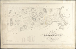
Map of the town of Brookline, Mass. : made by order of the town authorities from actual survey
58.
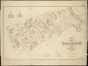
Map of the town of Brookline, Mass : surveyed in 1844 by order of the Town Authorities
59.
Plan of land owned by the Aspinwall Land Company on Aspinwall Hill in Brookline, Mass
60.
Plan of lands owned by The Aspinwall Land Company in Brookline : July 1886
‹ Prev
Next ›
1
2
3
4
5
6
7
…
443
444