Toggle navigation
LMEC Home
Exhibitions
Georeferencing
Tools for Teachers
Collections
My Favorites
Sign Up / Log In
Search
Search the map portal
Map Collection
Map Collection
Map Sets
Search
Search
Search for
Search In
All Fields
Creator
Title
Subject
Place
Search All Digital Collections
Advanced Search
8670 Results
My Search
Start Over
More Like
commonwealth:cj82kn950
Remove constraint More Like: commonwealth:cj82kn950
Filter your Search
Place
North and Central America
5,910
United States
4,829
Massachusetts
2,071
Europe
1,392
Suffolk (county)
1,042
Boston
1,015
Canada
455
Asia
437
more
Place
»
Topic
Boston (Mass.)--Maps
584
United States--Maps
279
Real property--Massachusetts--Boston--Maps
175
Massachusetts--Maps
162
Landowners--Massachusetts--Boston--Maps
133
New England--Maps
122
North America--Maps--Early works to 1800
103
Europe--Maps
79
more
Topic
»
Date
Date range begin
–
Date range end
Current results range from
1482
to
2023
View distribution
Creator
United States. Hydrographic Office
595
O.H. Bailey & Co
148
Des Barres, Joseph F. W. (Joseph Frederick Wallet), 1722-1824
123
United States. Post Office Dept
120
Ptolemy, 2nd cent
100
Walling, Henry Francis, 1825-1888
94
Geological Survey (U.S.)
86
Jefferys, Thomas, -1771
85
more
Creator
»
Format
Maps/Atlases
8,611
Manuscripts
215
Prints
56
Books
36
Objects/Artifacts
10
Drawings/Illustrations
8
Posters
4
Georeferenced
Yes
871
No
7,799
Collection
Norman B. Leventhal Map & Education Center Collection
8,648
Boston and New England Maps
2,226
Urban Maps
1,992
Maritime Charts and Atlases
1,083
American Revolutionary War-Era Maps
632
Boston Redevelopment Authority Collection
87
American Antiquarian Society Collection
9
William L. Clements Library Collection
6
more
Collection
»
Available to use
No known restrictions
8,506
Creative Commons license
50
Search Constraints
Sort by relevance
relevance
title
date (asc)
date (desc)
Number of results to display per page
20 per page
10
per page
20
per page
50
per page
100
per page
View results as:
grid view
map view
Search Results
2801.
The historical war map
2802.
History 2
2803.
Holbrook, Massachusetts, 1892 : incorporated Feb. 29, 1872
2804.
Holden, Massachusetts
2805.
Holland and Belgium
2806.
Hollandia comitatus
2807.
Hollandiae pars septentrionalis, vulgo Westuriesland et 't Noorder Quartier
2808.
Hollandiae septentrionalis & Frisiae occidentalis accuratissima delineatio
2809.
Holsatiae tabula generalis in qua sunt Ducatus Holsatiae, Dithmarsiae, Stormariae et Wagriae
2810.
Holy Cross National Forest, Colorado
2811.
Home rule map of Ireland
2812.
Honduras from a drawing by International Railways of Central America
2813.
Hope, Jackson, Fiskville and Arkwright, Rhode Island
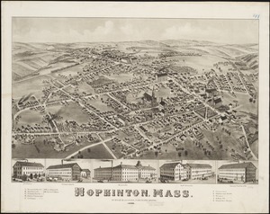
2814.
Hopkinton, Mass
2815.
Horta and Pim Bays, Fayal Id. Azores ; Fayal Channel, Azores
2816.
Hotbeds of contamination : the toxicity of our cities
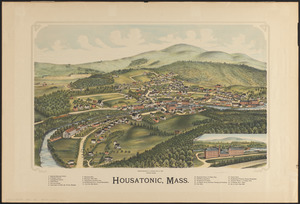
2817.
Housatonic, Mass.
2818.
How the public domain has been squandered, map showing the 139,403,026 acres of the people's land - equal to 871,268 farms of...
2819.
How we get around today
2820.
Hudsons Island ; Maraki or Matthews Island, Kingsmill Group ; Maiana or Halls Island, Kingsmill Group ; Apamama or Hoppers...
‹ Prev
Next ›
1
2
…
137
138
139
140
141
142
143
144
145
…
433
434