Toggle navigation
LMEC Home
Exhibitions
Georeferencing
Tools for Teachers
Collections
My Favorites
Sign Up / Log In
Search
Search the map portal
Map Collection
Map Collection
Map Sets
Search
Search
Search for
Search In
All Fields
Creator
Title
Subject
Place
Search All Digital Collections
Advanced Search
8683 Results
My Search
Start Over
More Like
commonwealth:9s161969s
Remove constraint More Like: commonwealth:9s161969s
Filter your Search
Place
North and Central America
5,922
United States
4,841
Massachusetts
2,068
Europe
1,392
Suffolk (county)
1,077
Boston
1,050
Canada
449
Asia
437
more
Place
»
Topic
Boston (Mass.)--Maps
591
United States--Maps
279
Real property--Massachusetts--Boston--Maps
212
Landowners--Massachusetts--Boston--Maps
169
Massachusetts--Maps
161
North America--Maps--Early works to 1800
103
New England--Maps
101
Europe--Maps
79
more
Topic
»
Date
Date range begin
–
Date range end
Current results range from
1482
to
2023
View distribution
Creator
United States. Hydrographic Office
595
O.H. Bailey & Co
148
Des Barres, Joseph F. W. (Joseph Frederick Wallet), 1722-1824
123
United States. Post Office Dept
120
Ptolemy, 2nd cent
100
Walling, Henry Francis, 1825-1888
94
Geological Survey (U.S.)
86
Bromley, George Washington
85
more
Creator
»
Format
Maps/Atlases
8,623
Manuscripts
215
Prints
56
Books
36
Objects/Artifacts
10
Drawings/Illustrations
8
Posters
5
Georeferenced
Yes
868
No
7,815
Collection
Norman B. Leventhal Map & Education Center Collection
8,646
Boston and New England Maps
2,223
Urban Maps
1,994
Maritime Charts and Atlases
1,083
American Revolutionary War-Era Maps
615
Boston Redevelopment Authority Collection
89
Massachusetts Real Estate Atlases
35
Available to use
No known restrictions
8,506
Creative Commons license
47
Search Constraints
Sort by relevance
relevance
title
date (asc)
date (desc)
Number of results to display per page
20 per page
10
per page
20
per page
50
per page
100
per page
View results as:
grid view
map view
Search Results
101.
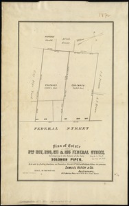
Plan of estate nos 207, 209, 211 & 215 Federal Street, belonging to the estate of the late Solomon Piper : to be sold at public...
102.
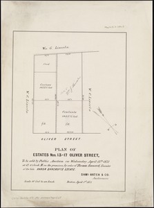
Plan of estates nos. 13-17 Oliver Street, to be sold by public auction on Wednesday April 12th 1871 at 12 o'clock m. on the...
103.
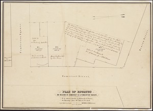
Plan of estates on Beacon St., Somerset St. & Pemberton Square : to be sold at auction by Whitwells & Seaver, on Thursday June...
104.
Plan of estates on Suffolk St. District : belonging to the City of Boston : to be sold at public auction, Dec. 23rd 1871
105.
Plan of estates on Suffolk St. district : belonging to the City of Boston : to be sold at public auction on Saturday Dec. 16th...
106.
Plan of Hoosac Tunnel Dock and Elevator Company's docks and land in Charlestown, Mass.
107.
Plan of house lots in Boston belonging to Otis H. Weed
108.
Plan of land and street layout in Boston, Mass., Hyde Park : prepared for the Stoney Brook Land Trust
109.
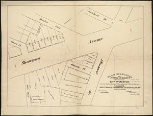
Plan of land on West Chester Park and Huntington Ave. belonging to the Boston Water Power Co
110.
Plan of lands belonging to the Boston Water Power Company
111.
Plan of lands belonging to the Boston Water Power Company and the Commonwealth, on the Back Bay, showing part of the city...
112.
Plan of lands belonging to the Commonwealth of Massachusetts
113.
[Plan of lots between Mount Vernon and Pinckney Streets in Boston]
114.
[Plan of lots for sale on Morton and Milk Streets, Boston]
115.
[Plan of lots for sale on Pearl Street in Boston]
116.
[Plan of lots in South Boston]
117.
[Plan of lots on Beacon Street and Somerset Court, Boston]
118.
Plan of lots on Fort Hill district, belonging to the City of Boston : to be sold at public auction, on Wednesday, April 15th at...
119.
[Plan of lots on Park, Beacon and Tremont Streets in Boston]
120.
Plan of Mercantile Wharf property in Boston Mass : showing 5 lots of land thereon to be sold at public auction on Tuesday April...
‹ Prev
Next ›
1
2
3
4
5
6
7
8
9
10
…
434
435


![[Plan of lots between Mount Vernon and Pinckney Streets in Boston]](https://bpldcassets.blob.core.windows.net/derivatives/images/commonwealth:9s161h42m/image_thumbnail_300.jpg)
![[Plan of lots for sale on Morton and Milk Streets, Boston]](https://bpldcassets.blob.core.windows.net/derivatives/images/commonwealth:9s161h52v/image_thumbnail_300.jpg)
![[Plan of lots for sale on Pearl Street in Boston]](https://bpldcassets.blob.core.windows.net/derivatives/images/commonwealth:9s161h54d/image_thumbnail_300.jpg)
![[Plan of lots in South Boston]](https://bpldcassets.blob.core.windows.net/derivatives/images/commonwealth:9s161h046/image_thumbnail_300.jpg)
![[Plan of lots on Beacon Street and Somerset Court, Boston]](https://bpldcassets.blob.core.windows.net/derivatives/images/commonwealth:9s161h18j/image_thumbnail_300.jpg)

![[Plan of lots on Park, Beacon and Tremont Streets in Boston]](https://bpldcassets.blob.core.windows.net/derivatives/images/commonwealth:9s161j64v/image_thumbnail_300.jpg)
