Toggle navigation
LMEC Home
Exhibitions
Georeferencing
Tools for Teachers
Collections
My Favorites
Sign Up / Log In
Search
Search the map portal
Map Collection
Map Collection
Map Sets
Search
Search
Search for
Search In
All Fields
Creator
Title
Subject
Place
Search All Digital Collections
Advanced Search
8876 Results
My Search
Start Over
More Like
commonwealth:8336h2581
Remove constraint More Like: commonwealth:8336h2581
Filter your Search
Place
North and Central America
6,107
United States
5,023
Massachusetts
2,148
Europe
1,396
Suffolk (county)
1,210
Boston
1,183
Canada
449
Asia
438
more
Place
»
Topic
Boston (Mass.)--Maps
752
United States--Maps
282
Real property--Massachusetts--Boston--Maps
195
Massachusetts--Maps
166
City planning--Massachusetts--Boston--Maps
158
Landowners--Massachusetts--Boston--Maps
142
New England--Maps
104
North America--Maps--Early works to 1800
103
more
Topic
»
Date
Date range begin
–
Date range end
Current results range from
1482
to
2023
View distribution
Creator
United States. Hydrographic Office
595
Boston Redevelopment Authority
162
O.H. Bailey & Co
148
Des Barres, Joseph F. W. (Joseph Frederick Wallet), 1722-1824
124
United States. Post Office Dept
120
Ptolemy, 2nd cent
100
Walling, Henry Francis, 1825-1888
94
Geological Survey (U.S.)
87
more
Creator
»
Format
Maps/Atlases
8,816
Manuscripts
215
Prints
56
Books
36
Objects/Artifacts
10
Drawings/Illustrations
8
Posters
6
Georeferenced
Yes
885
No
7,991
Collection
Norman B. Leventhal Map & Education Center Collection
8,732
Boston and New England Maps
2,367
Urban Maps
2,142
Maritime Charts and Atlases
1,088
American Revolutionary War-Era Maps
643
Boston Redevelopment Authority Collection
192
Mapping Boston Collection
28
William L. Clements Library Collection
15
more
Collection
»
Available to use
No known restrictions
8,666
Creative Commons license
78
Search Constraints
Sort by relevance
relevance
title
date (asc)
date (desc)
Number of results to display per page
20 per page
10
per page
20
per page
50
per page
100
per page
View results as:
grid view
map view
Search Results
541.
Plan of the basins belonging to the Boston Water-Power Comp
542.
Plan of the Brooks estate corner of Court & Washington Street : to be sold at public auction, at the Merchants Exchange Reading...
543.
Plan of the burnt district : showing proposed improvements in streets. Nov. 12th 1872
544.
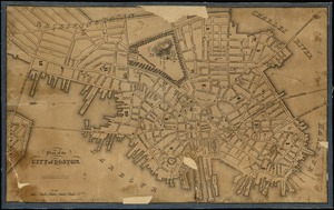
Plan of the city of Boston
545.
Plan of the city of Boston
546.
Plan of the city of Boston
547.
Plan of the city of Boston
548.
Plan of the city of Boston
549.
Plan of the city of Boston
550.
Plan of the city of Boston
551.
Plan of the city of Boston
552.
Plan of the city of Boston
553.
Plan of the city of Boston
554.
Plan of the city of Boston
555.
Plan of the Coffin Estate, corner of Summer and Chauncy Streets : to be sold by public auction on Wednesday April 26th 1856 at...
556.
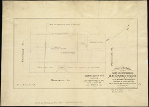
Plan of the estate of late Doct. John W. Warren, No. 89 Harrison Avenue, cor. of Kneeland St. & Plymouth Pl. to be sold at...
557.
Plan of the estate of the late Warren White : to be sold at public auction on Wednesday March 27th 1872 at 12 o'clock m. on the...
558.
Plan of the estate on the southerly corner of Washington and Franklin Streets : to be sold by public auction on Saturday June...
559.
Plan of the estates nos. 246 to 252 Congress corner of Purchase Street and nos. 59 to 69 Purchase Street : to be sold by public...
560.
Plan of the Federal St. Meeting House estate : to be sold by public auction, on Thursday February 24th 1859, at 12 o'clock noon...
‹ Prev
Next ›
1
2
…
24
25
26
27
28
29
30
31
32
…
443
444