Toggle navigation
LMEC Home
Exhibitions
Georeferencing
Tools for Teachers
Collections
My Favorites
Sign Up / Log In
Search
Search the map portal
Map Collection
Map Collection
Map Sets
Search
Search
Search for
Search In
All Fields
Creator
Title
Subject
Place
Search All Digital Collections
Advanced Search
1223 Results
My Search
Start Over
More Like
commonwealth:7h14cw30x
Remove constraint More Like: commonwealth:7h14cw30x
Filter your Search
Place
North and Central America
1,219
United States
1,214
Suffolk (county)
1,199
Boston
1,198
Massachusetts
864
Roxbury
83
South End
61
Charlestown
53
more
Place
»
Topic
Boston (Mass.)--Maps
752
City planning--Massachusetts--Boston--Maps
418
Real property--Massachusetts--Boston--Maps
253
Urban renewal--Massachusetts--Boston--Maps
253
Landowners--Massachusetts--Boston--Maps
160
Buildings--Massachusetts--Boston--Maps
125
Land use--Massachusetts--Boston--Maps
102
Roxbury (Boston, Mass.)--Maps
82
more
Topic
»
Date
Date range begin
–
Date range end
Current results range from
1743
to
2023
View distribution
Creator
Boston Redevelopment Authority
393
Bromley, George Washington
69
Bromley, Walter Scott
68
G.W. Bromley & Co.
46
Geo. H. Walker & Co
27
Boynton, George W., d. 1884
21
Sampson, Davenport & Co
21
Sampson, Murdock & Co
20
more
Creator
»
Format
Maps/Atlases
1,222
Manuscripts
10
Drawings/Illustrations
3
Prints
1
Georeferenced
Yes
104
No
1,119
Collection
Boston and New England Maps
1,016
Urban Maps
916
Norman B. Leventhal Map & Education Center Collection
776
Boston Redevelopment Authority Collection
456
Massachusetts Real Estate Atlases
38
American Revolutionary War-Era Maps
26
Mapping Boston Collection
20
William L. Clements Library Collection
10
more
Collection
»
Available to use
No known restrictions
1,127
Creative Commons license
36
Search Constraints
Sort by relevance
relevance
title
date (asc)
date (desc)
Number of results to display per page
20 per page
10
per page
20
per page
50
per page
100
per page
View results as:
grid view
map view
Search Results
301.
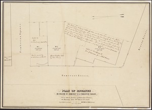
Plan of building lots on Phillips Place, Tremont & Somerset Streets
302.
Plan of building lots on Washington, Waltham & Parker Streets and Harrison Avenue, belonging to the Boston Lying-In Hospital...
303.
Plan of city lands to be sold Oct. 30th 1850
304.
Plan of City Wharf in Boston, Mass : shewing 14 lots of land on the side of the south dock of said wharf & Commercial St. : to...
305.
Plan of estate, nos 1043 to 1059 Washington Street, Boston, belonging to the heirs of the late William Brigham : to be sold by...
306.
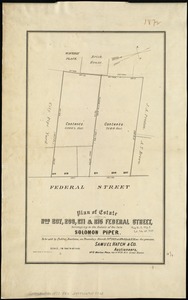
Plan of estate nos 207, 209, 211 & 215 Federal Street, belonging to the estate of the late Solomon Piper : to be sold at public...
307.
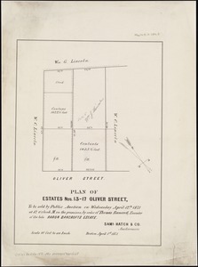
Plan of estates nos. 13-17 Oliver Street, to be sold by public auction on Wednesday April 12th 1871 at 12 o'clock m. on the...
308.
Plan of estates on Beacon St., Somerset St. & Pemberton Square : to be sold at auction by Whitwells & Seaver, on Thursday June...
309.
Plan of estates on Suffolk St. District : belonging to the City of Boston : to be sold at public auction, Dec. 23rd 1871
310.
Plan of Fort Hill showing street improvements as adopted by the city council : 1869
311.
Plan of Gray's Wharf, to be sold at public auction, on the premises, on Thursday April 28th 1870 at 12 o'clock noon
312.
Plan of land & wharves belonging to Mill Pond Wharf Co. near Bartons Point
313.
Plan of land on Bedford and Avon Streets belonging to the proprietors of the Second Church in Boston : to be sold by public...
314.
Plan of lands belonging to the Commonwealth of Massachusetts
315.
Plan of lands on the Back Bay belonging to the Boston Water Power Co., the Commonwealth and other parthies [i.e. parties],...
316.
[Plan of lots between Mount Vernon and Pinckney Streets in Boston]
317.
[Plan of lots for sale on Morton and Milk Streets, Boston]
318.
[Plan of lots for sale on Pearl Street in Boston]
319.
[Plan of lots in Chinatown (Boston), between Avery and Eliot Streets, and Tremont Street and Harrison Avenue]
320.
[Plan of lots in South Boston]
‹ Prev
Next ›
1
2
…
12
13
14
15
16
17
18
19
20
…
61
62


![Plan of lands on the Back Bay belonging to the Boston Water Power Co., the Commonwealth and other parthies [i.e. parties], showing the system of streets, grades and sewers as laid out and recommended by the Back Bay Commissioners](https://bpldcassets.blob.core.windows.net/derivatives/images/commonwealth:1257bb305/image_thumbnail_300.jpg)
![[Plan of lots between Mount Vernon and Pinckney Streets in Boston]](https://bpldcassets.blob.core.windows.net/derivatives/images/commonwealth:9s161h42m/image_thumbnail_300.jpg)
![[Plan of lots for sale on Morton and Milk Streets, Boston]](https://bpldcassets.blob.core.windows.net/derivatives/images/commonwealth:9s161h52v/image_thumbnail_300.jpg)
![[Plan of lots for sale on Pearl Street in Boston]](https://bpldcassets.blob.core.windows.net/derivatives/images/commonwealth:9s161h54d/image_thumbnail_300.jpg)
![[Plan of lots in Chinatown (Boston), between Avery and Eliot Streets, and Tremont Street and Harrison Avenue]](https://bpldcassets.blob.core.windows.net/derivatives/images/commonwealth:cj82kz565/image_thumbnail_300.jpg)
![[Plan of lots in South Boston]](https://bpldcassets.blob.core.windows.net/derivatives/images/commonwealth:9s161h046/image_thumbnail_300.jpg)