Toggle navigation
LMEC Home
Exhibitions
Georeferencing
Tools for Teachers
Collections
My Favorites
Sign Up / Log In
Search
Search the map portal
Map Collection
Map Collection
Map Sets
Search
Search
Search for
Search In
All Fields
Creator
Title
Subject
Place
Search All Digital Collections
Advanced Search
8275 Results
My Search
Start Over
More Like
commonwealth:6h446t70w
Remove constraint More Like: commonwealth:6h446t70w
Filter your Search
Place
North and Central America
5,024
United States
3,856
Suffolk (county)
1,138
Boston
1,111
Europe
963
Canada
427
Massachusetts
304
France
269
more
Place
»
Topic
Boston (Mass.)--Maps
595
United States--Maps
270
Real property--Massachusetts--Boston--Maps
252
Landowners--Massachusetts--Boston--Maps
169
Massachusetts--Maps
160
City planning--Massachusetts--Boston--Maps
135
North America--Maps--Early works to 1800
103
New England--Maps
99
more
Topic
»
Date
Date range begin
–
Date range end
Current results range from
1482
to
2023
View distribution
Creator
United States. Hydrographic Office
357
O.H. Bailey & Co
148
Boston Redevelopment Authority
138
Des Barres, Joseph F. W. (Joseph Frederick Wallet), 1722-1824
123
United States. Post Office Dept
120
Ptolemy, 2nd cent
100
Walling, Henry Francis, 1825-1888
94
Bromley, George Washington
85
more
Creator
»
Format
Maps/Atlases
8,216
Manuscripts
215
Prints
51
Books
36
Objects/Artifacts
10
Drawings/Illustrations
8
Posters
4
Georeferenced
Yes
870
No
7,405
Collection
Norman B. Leventhal Map Center Collection
8,164
Boston and New England Maps
2,261
Urban Maps
2,002
Maritime Charts and Atlases
750
American Revolutionary War-Era Maps
616
Boston Redevelopment Authority Collection
162
Massachusetts Real Estate Atlases
35
Mapping Boston Collection
1
Available to use
No known restrictions
8,098
Creative Commons license
47
Search Constraints
Sort by date (desc)
relevance
title
date (asc)
date (desc)
Number of results to display per page
50 per page
10
per page
20
per page
50
per page
100
per page
View results as:
grid view
map view
Search Results
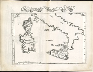
8201.
Tabula moderna Italie
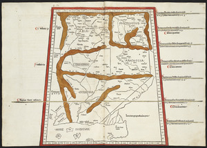
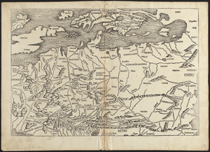
8202.
Tabula V Asiae
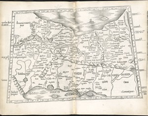
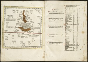
8203.
Tabula V Europae
8204.
Tabula VI Asiae
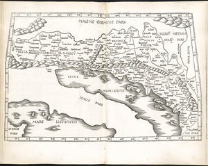
8205.
Tabula VI Europae
8206.
Tabula VII Asiae
8207.
Tabula VII Europae
8208.
Tabula VIII Asiae
8209.
Tabula VIII Europae
8210.
Tabula X Asiae
8211.
Tabula X Europae
8212.
Tabula XI Asiae
8213.
Tabula XII Asiae
8214.
[The World]
8215.
Decima Asiae tabula
8216.
Decima et ultima Europae tabula
8217.
Duodecima Asiae tabula
8218.
Nona Asiae tabula
8219.
Nona Europae tabula
8220.
Octava Asiae tabula
8221.
Octava Europae tabula
8222.
Prima Africae tabula
8223.
Prima Europae tabula
8224.
Quarta Africae tabula
8225.
Quarta Asiae tabula
8226.
Quarta Europae tabula
8227.
Quinta Asiae tabula
8228.
Quinta Europae tabula
8229.
Secunda Africae tabula
8230.
Secunda Asiae tabula
8231.
Secunda Europae tabula
8232.
Septima Asiae tabula
8233.
Septima Europae tabula
8234.
Sexta Asiae tabula
8235.
Sexta Europae tabula
8236.
Tertia Africae tabula
8237.
Tertia Asiae tabula
8238.
Tertia Europae tabula
8239.
[The World]
8240.
Undecima Asiae tabula
8241.
[World map]
8242.
Europe
8243.
Leaves from Liber chronicarum, with views of de Sarmatia regione Europe, Cracovia, Lubeca and Nissa
8244.
Affrice Tabule Quatuor : Prima Libie tabula continet ambas Mauritanias
8245.
Decima Europe tabula continent Macedonia et Epirum et Achaiam & Peloponesum
8246.
Duodecima et Ultima Asie tabula continet Taprobana insulam cum certeris insulis adiacentibus
8247.
[Frantia]
8248.
[Hispania]
8249.
Indie interioris civitates decima Asia tabula continet India int. Gangem
8250.
Nona Asie tabula continet Ariam & Paropanisadas & Drangianam & Arachosia & Gedrosiam
‹ Prev
Next ›
1
2
…
161
162
163
164
165
166