Toggle navigation
LMEC Home
Exhibitions
Georeferencing
Tools for Teachers
Collections
My Favorites
Sign Up / Log In
Search
Search the map portal
Map Collection
Map Collection
Map Sets
Search
Search
Search for
Search In
All Fields
Creator
Title
Subject
Place
Search All Digital Collections
Advanced Search
9133 Results
My Search
Start Over
More Like
commonwealth:4m90fp184
Remove constraint More Like: commonwealth:4m90fp184
Filter your Search
Place
North and Central America
6,364
United States
5,280
Massachusetts
2,195
Suffolk (county)
1,471
Boston
1,444
Europe
1,396
Canada
449
Asia
438
more
Place
»
Topic
Boston (Mass.)--Maps
752
City planning--Massachusetts--Boston--Maps
418
United States--Maps
282
Urban renewal--Massachusetts--Boston--Maps
252
Real property--Massachusetts--Boston--Maps
225
Massachusetts--Maps
166
Landowners--Massachusetts--Boston--Maps
144
New England--Maps
104
more
Topic
»
Date
Date range begin
–
Date range end
Current results range from
1482
to
2023
View distribution
Creator
United States. Hydrographic Office
595
Boston Redevelopment Authority
399
O.H. Bailey & Co
148
Des Barres, Joseph F. W. (Joseph Frederick Wallet), 1722-1824
124
United States. Post Office Dept
120
Ptolemy, 2nd cent
100
Walling, Henry Francis, 1825-1888
94
Geological Survey (U.S.)
87
more
Creator
»
Format
Maps/Atlases
9,073
Manuscripts
214
Prints
56
Books
36
Objects/Artifacts
10
Drawings/Illustrations
8
Posters
5
Georeferenced
Yes
886
No
8,247
Collection
Norman B. Leventhal Map & Education Center Collection
8,725
Boston and New England Maps
2,623
Urban Maps
2,405
Maritime Charts and Atlases
1,083
American Revolutionary War-Era Maps
638
Boston Redevelopment Authority Collection
455
Mapping Boston Collection
20
Massachusetts Real Estate Atlases
18
more
Collection
»
Available to use
No known restrictions
8,930
Creative Commons license
70
Search Constraints
Sort by relevance
relevance
title
date (asc)
date (desc)
Number of results to display per page
20 per page
10
per page
20
per page
50
per page
100
per page
View results as:
grid view
map view
Search Results
181.
Atlas of the city of Cambridge, Massachusetts : from actual surveys and official plans
182.
Atlas of the city of Cambridge, Massachusetts : from official records, private plan and actual surveys
183.
Atlas of the city of Cambridge, Massachusetts : from actual surveys and official plans
184.
Atlas of the city of Cambridge, Middlesex Co., Massachusetts
185.
Broad Canal, Cambridge : condition of retaining walls and bed of Canal, inspection for Committee on Charles River Dam, Oct. 30,...
186.
Compiled plan, showing Millers Creek and a portion of Charles River
187.
Insurance map of Charlestown : portions of Roxbury (now annexed to Boston) and Cambridge : 1868 : corrected Nov. 1871
188.
Insurance map of Charlestown : portions of Roxbury (now annexed to Boston) and Cambridge
189.
Insurance maps of Boston volume 4 : comprising portions of Charlestown, East Cambridge, Cambridge Port, Old Cambridge & Somerville
190.
Lechmere Canal, Cambridge : condition of retaining walls and bed of canal, inspection for Committee on Charles River Dam, Nov....
191.
Map of Cambridge
192.
Map of Cambridge in the vicinity of Harvard College 1903-4
193.
A map of Cambridge, Mass
194.
Map of Cambridge Massachusetts
195.
Map of Cambridge roads, about 1807
196.
Map of Fresh Pond : showing the division lines of the proprietors extended into the pond and defining their right to the same...
197.
Map of part of Cambridge, Mass
198.
Map of the cemetery of Mount Auburn, Boston
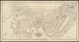
199.
Map of the city of Cambridge
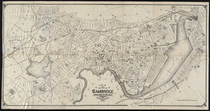
200.
Map of the city of Cambridge
‹ Prev
Next ›
1
2
…
6
7
8
9
10
11
12
13
14
…
456
457