Toggle navigation
LMEC Home
Exhibitions
Georeferencing
Tools for Teachers
Collections
My Favorites
Sign Up / Log In
Search
Search the map portal
Map Collection
Map Collection
Map Sets
Search
Search
Search for
Search In
All Fields
Creator
Title
Subject
Place
Search All Digital Collections
Advanced Search
8889 Results
My Search
Start Over
More Like
commonwealth:3f4636930
Remove constraint More Like: commonwealth:3f4636930
Filter your Search
Place
North and Central America
6,120
United States
5,036
Massachusetts
2,135
Europe
1,396
Suffolk (county)
1,235
Boston
1,208
Canada
449
Asia
438
more
Place
»
Topic
Boston (Mass.)--Maps
752
United States--Maps
282
Real property--Massachusetts--Boston--Maps
223
Landowners--Massachusetts--Boston--Maps
169
Massachusetts--Maps
166
City planning--Massachusetts--Boston--Maps
159
New England--Maps
104
North America--Maps--Early works to 1800
103
more
Topic
»
Date
Date range begin
–
Date range end
Current results range from
1482
to
2023
View distribution
Creator
United States. Hydrographic Office
595
Boston Redevelopment Authority
163
O.H. Bailey & Co
148
Des Barres, Joseph F. W. (Joseph Frederick Wallet), 1722-1824
124
United States. Post Office Dept
120
Ptolemy, 2nd cent
100
Walling, Henry Francis, 1825-1888
94
Geological Survey (U.S.)
87
more
Creator
»
Format
Maps/Atlases
8,829
Manuscripts
215
Prints
56
Books
36
Objects/Artifacts
10
Drawings/Illustrations
8
Posters
5
Georeferenced
Yes
885
No
8,004
Collection
Norman B. Leventhal Map & Education Center Collection
8,723
Boston and New England Maps
2,359
Urban Maps
2,143
Maritime Charts and Atlases
1,083
American Revolutionary War-Era Maps
638
Boston Redevelopment Authority Collection
193
Massachusetts Real Estate Atlases
38
Mapping Boston Collection
20
more
Collection
»
Available to use
No known restrictions
8,666
Creative Commons license
70
Search Constraints
Sort by relevance
relevance
title
date (asc)
date (desc)
Number of results to display per page
20 per page
10
per page
20
per page
50
per page
100
per page
View results as:
grid view
map view
Search Results
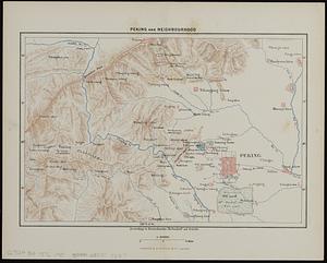
6241.
Peking and neighbourhood
6242.
Peloponnesus hodie Moreae Regnum : distincté divisum in omnes suas provincias, hodiernas atque veteres, cui et adiuguntur...
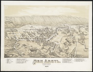
6243.
Pen Argyl : Pennsylvania
6244.
Penacook, N.H
6245.
Pend Oreille National Forest, Idaho
6246.
Pennsylvania
6247.
Pennsylvania
6248.
Pensylvania Nova Jersey et Nova York cum Regionibus ad Fluvium Delaware in America sitis
6249.
A people's map of Lawrence, Massachusetts
6250.
Peoples of the Pacific
6251.
The people's republic of Cambridge
6252.
Pepin County, Wis.
6253.
Perigrinatie ofte veertich-iarige reyse der kindern Israëls, uyt Egypten door de Roode Zee, ende de woestyne, tot in't...
6254.
Le Perou : et le cours de la rivière Amazone, depuis ses sources jusques à la mer
6255.
Perrine's new topographical war map of the southern states : taken from the latest government surveys and official reports
6256.
Perspective view of Bunker Hill Monument
6257.
A perspective view of Lake George : Plan of Ticonderoga
6258.
Peru
6259.
Peru
6260.
Peru
‹ Prev
Next ›
1
2
…
309
310
311
312
313
314
315
316
317
…
444
445