Toggle navigation
LMEC Home
Exhibitions
Georeferencing
Tools for Teachers
Collections
My Favorites
Sign Up / Log In
Search
Search the map portal
Map Collection
Map Collection
Map Sets
Search
Search
Search for
Search In
All Fields
Creator
Title
Subject
Place
Search All Digital Collections
Advanced Search
8886 Results
My Search
Start Over
More Like
commonwealth:1257bp07f
Remove constraint More Like: commonwealth:1257bp07f
Filter your Search
Place
North and Central America
6,130
United States
5,048
Massachusetts
2,124
Europe
1,388
Suffolk (county)
1,282
Boston
1,255
Canada
449
Asia
436
more
Place
»
Topic
Boston (Mass.)--Maps
747
United States--Maps
279
Real property--Massachusetts--Boston--Maps
254
City planning--Massachusetts--Boston--Maps
208
Landowners--Massachusetts--Boston--Maps
170
Massachusetts--Maps
165
Urban renewal--Massachusetts--Boston--Maps
111
New England--Maps
103
more
Topic
»
Date
Date range begin
–
Date range end
Current results range from
1482
to
2023
View distribution
Creator
United States. Hydrographic Office
595
Boston Redevelopment Authority
209
O.H. Bailey & Co
148
Des Barres, Joseph F. W. (Joseph Frederick Wallet), 1722-1824
124
United States. Post Office Dept
120
Ptolemy, 2nd cent
100
Walling, Henry Francis, 1825-1888
94
Geological Survey (U.S.)
87
more
Creator
»
Format
Maps/Atlases
8,827
Manuscripts
215
Prints
56
Books
36
Objects/Artifacts
10
Drawings/Illustrations
8
Posters
4
Georeferenced
Yes
885
No
8,001
Collection
Norman B. Leventhal Map & Education Center Collection
8,668
Boston and New England Maps
2,399
Urban Maps
2,159
Maritime Charts and Atlases
1,083
American Revolutionary War-Era Maps
638
Boston Redevelopment Authority Collection
245
Massachusetts Real Estate Atlases
38
Mapping Boston Collection
20
more
Collection
»
Available to use
No known restrictions
8,663
Creative Commons license
70
Search Constraints
Sort by relevance
relevance
title
date (asc)
date (desc)
Number of results to display per page
20 per page
10
per page
20
per page
50
per page
100
per page
View results as:
grid view
map view
Search Results
3941.
Louisiana
3942.
Louisiana, a dream state
3943.
La Louisiana, parte settentrionalle, scoperta sotto la protettione di Luigi XIV, Ré di Francia, etc
3944.
Lovell's map of the city of Montreal : including Westmount, Outremount, Verdun, Montreal West and St. Laurent
3945.
Low Archipelago or Paumotu Group
3946.
Ludlow, Vt
3947.
Lugdunensis Prima, cujus metropolis Lugdunum Segusianorum : Province de Lyon ou sont les dioeceses de l'Archevesche de Lyon, et...
3948.
Lumberman's map of northern Maine
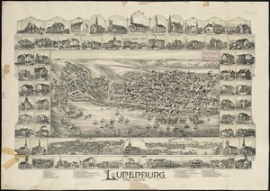
3949.
Lunenburg, Nova Scotia
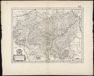
3950.
Lutzenburg Ducatus
3951.
Lyndonville, Caledonia County, Vermont : 1884
3952.
Lynn, Mass [art original] : west view from near High Rock
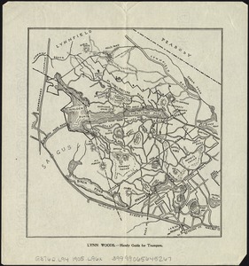
3953.
Lynn Woods : handy guide for trampers
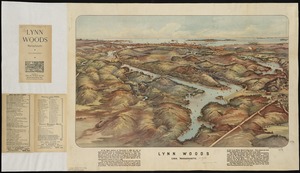
3954.
Lynn Woods : Lynn, Massachusetts
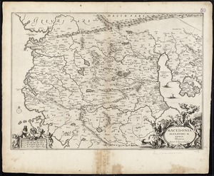
3955.
Macedonia Alexandri M. Patria Illustris
3956.
Macedonia, Epirus et Achaia
3957.
Madagascar--n.w. coast, Bavatoubé Bay (Dalrymple Bay)
3958.
Madeira, Porto Santo and Dezertas : from British surveys in 1843, corrected to 1871
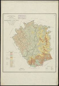
3959.
Madison County
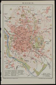
3960.
Madrid
‹ Prev
Next ›
1
2
…
194
195
196
197
198
199
200
201
202
…
444
445


![Lynn, Mass [art original]](https://bpldcassets.blob.core.windows.net/derivatives/images/commonwealth:9s161g34q/image_thumbnail_300.jpg)