Toggle navigation
LMEC Home
Exhibitions
Georeferencing
Tools for Teachers
Collections
My Favorites
Sign Up / Log In
Search
Search the map portal
Map Collection
Map Collection
Map Sets
Search
Search
Search for
Search In
All Fields
Creator
Title
Subject
Place
Search All Digital Collections
Advanced Search
8800 Results
My Search
Start Over
More Like
commonwealth:1257bn95v
Remove constraint More Like: commonwealth:1257bn95v
Filter your Search
Place
North and Central America
6,095
United States
5,017
Massachusetts
2,135
Europe
1,359
Suffolk (county)
1,280
Boston
1,253
Canada
448
Asia
422
more
Place
»
Topic
Boston (Mass.)--Maps
741
United States--Maps
273
Real property--Massachusetts--Boston--Maps
252
City planning--Massachusetts--Boston--Maps
213
Landowners--Massachusetts--Boston--Maps
169
Massachusetts--Maps
163
North America--Maps--Early works to 1800
103
Urban renewal--Massachusetts--Boston--Maps
103
more
Topic
»
Date
Date range begin
–
Date range end
Current results range from
1482
to
2023
View distribution
Creator
United States. Hydrographic Office
594
Boston Redevelopment Authority
219
O.H. Bailey & Co
148
Des Barres, Joseph F. W. (Joseph Frederick Wallet), 1722-1824
124
United States. Post Office Dept
120
Ptolemy, 2nd cent
100
Walling, Henry Francis, 1825-1888
94
Geological Survey (U.S.)
87
more
Creator
»
Format
Maps/Atlases
8,741
Manuscripts
215
Prints
56
Books
36
Objects/Artifacts
10
Drawings/Illustrations
8
Posters
4
Georeferenced
Yes
885
No
7,915
Collection
Norman B. Leventhal Map & Education Center Collection
8,576
Boston and New England Maps
2,386
Urban Maps
2,115
Maritime Charts and Atlases
1,081
American Revolutionary War-Era Maps
638
Boston Redevelopment Authority Collection
251
Massachusetts Real Estate Atlases
38
Mapping Boston Collection
20
more
Collection
»
Available to use
No known restrictions
8,578
Creative Commons license
69
Search Constraints
Sort by date (asc)
relevance
title
date (asc)
date (desc)
Number of results to display per page
20 per page
10
per page
20
per page
50
per page
100
per page
View results as:
grid view
map view
Search Results
8381.
Central business district project no Mass r- : existing land use
8382.
Central business district project no Mass r- : existing building condition
8383.
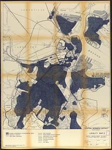
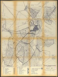
Central business district project no Mass r- : locality map 2
8384.
Central business district project no Mass r- : locality map 1
8385.
City of Boston : topographic and planimetric survey
8386.
City of Boston topographic and planimetric survey
8387.
Downtown existing buildings conditions
8388.
Downtown Waterfront Faneuil Hall renewal area : locality map 1
8389.
Downtown Waterfront-Faneuil Hall renewal area : locality map 2
8390.
Locality map
8391.
Route chart showing routes to and from northwestern Europe
8392.
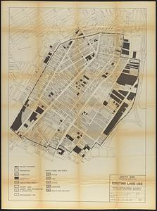
South End project no. Mass. r-56 : existing land use
8393.
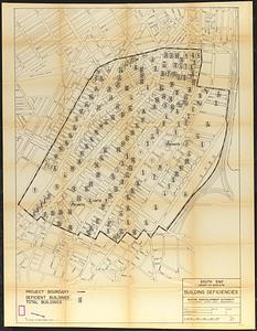
South End project no. Mass. r-56 : building deficiencies
8394.
Zoning districts, city of Boston
8395.
Downtown Waterfront-Faneuil Hall renewal area : existing land use
8396.
Downtown Waterfront-Faneuil Hall renewal area : building conditions
8397.
Zoning districts - city of Boston - map 1 - Boston proper
8398.
Mattapan project : property map
8399.
Washington Park urban renewal area r-24 : property map
8400.
Building deficiencies map : Government Center project no. Mass. R-35
‹ Prev
Next ›
1
2
…
416
417
418
419
420
421
422
423
424
…
439
440