Toggle navigation
LMEC Home
Exhibitions
Georeferencing
Tools for Teachers
Collections
My Favorites
Sign Up / Log In
Search
Search the map portal
Map Collection
Map Collection
Map Sets
Search
Search
Search for
Search In
All Fields
Creator
Title
Subject
Place
Search All Digital Collections
Advanced Search
8934 Results
My Search
Start Over
More Like
commonwealth:0z7093608
Remove constraint More Like: commonwealth:0z7093608
Filter your Search
Place
North and Central America
6,165
United States
5,069
Massachusetts
2,204
Europe
1,396
Suffolk (county)
1,211
Boston
1,184
Canada
450
Asia
438
more
Place
»
Topic
Boston (Mass.)--Maps
752
United States--Maps
282
Massachusetts--Maps
235
Real property--Massachusetts--Boston--Maps
195
City planning--Massachusetts--Boston--Maps
159
Landowners--Massachusetts--Boston--Maps
142
New England--Maps
106
North America--Maps--Early works to 1800
103
more
Topic
»
Date
Date range begin
–
Date range end
Current results range from
1482
to
2023
View distribution
Creator
United States. Hydrographic Office
595
Boston Redevelopment Authority
164
O.H. Bailey & Co
148
Des Barres, Joseph F. W. (Joseph Frederick Wallet), 1722-1824
124
United States. Post Office Dept
120
Ptolemy, 2nd cent
100
Walling, Henry Francis, 1825-1888
95
Geological Survey (U.S.)
92
more
Creator
»
Format
Maps/Atlases
8,873
Manuscripts
217
Prints
56
Books
36
Objects/Artifacts
10
Drawings/Illustrations
8
Posters
5
Ephemera
1
Georeferenced
Yes
894
No
8,040
Collection
Norman B. Leventhal Map & Education Center Collection
8,765
Boston and New England Maps
2,405
Urban Maps
2,146
Maritime Charts and Atlases
1,083
American Revolutionary War-Era Maps
657
Boston Redevelopment Authority Collection
196
Mapping Boston Collection
22
Applied Geographics, Inc. Records
21
more
Collection
»
Available to use
No known restrictions
8,709
Creative Commons license
73
Search Constraints
Sort by relevance
relevance
title
date (asc)
date (desc)
Number of results to display per page
20 per page
10
per page
20
per page
50
per page
100
per page
View results as:
grid view
map view
Search Results
181.
Major transportation system : Boston region MAPC area
182.
South Boston urban renewal area r-51 : proposed circulation
183.
South Boston urban renewal area r-51 : existing circulation
184.
Atlas of the city of Boston : Boston proper : from actual surveys and official plans
185.
Atlas of the city of Boston : Boston proper and Back Bay : from actual surveys and official plans
186.
Atlas of the city of Boston : Boston proper and Back Bay : from actual surveys and official plans
187.
Atlas of the city of Boston : Boston proper and Back Bay : from actual surveys and official plans
188.
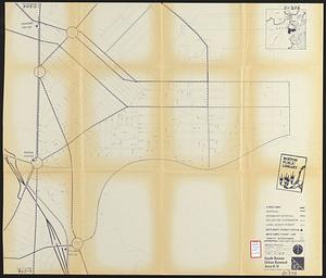
Atlas of the city of Boston : Boston proper and Back Bay : from actual surveys and official plans
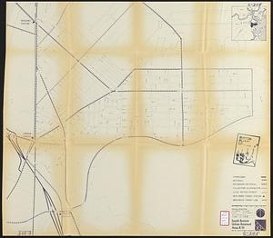
189.
Atlas of the city of Boston : Boston proper and Back Bay : from actual surveys and official plans
190.
Atlas of the city of Boston : Boston proper and Back Bay : from actual surveys and official plans
191.
Atlas of the city of Boston : Boston proper and Back Bay : from actual surveys and official plans
192.
Atlas of the city of Boston : Boston proper and Roxbury : from actual surveys and official plans
193.
Atlas of the city of Boston : city proper : volume 1 : from actual surveys and official records
194.
Atlas of the city of Boston : city proper and Roxbury : from actual surveys and official plans
195.
Atlas of the city of Boston : city proper, volume one : from actual surveys and official plans
196.
Atlas of the city of Boston : city proper, volume two : from actual surveys and official plans
197.
Atlas of the city of Boston : Roxbury : from actual surveys and official plans
198.
Atlas of the county of Suffolk, Massachusetts : vol. 1st including Boston proper : from actual surveys and official records
199.
Ausicht von Boston : nach der natur aufgenommen
200.
Back Bay and Parker Hill parks : Parker Hill and Jamaica parkways : Boston and Roxbury districts
‹ Prev
Next ›
1
2
…
6
7
8
9
10
11
12
13
14
…
446
447