Toggle navigation
LMEC Home
Exhibitions
Georeferencing
Tools for Teachers
Collections
My Favorites
Sign Up / Log In
Search
Search the map portal
Map Collection
Map Collection
Map Sets
Search
Search
Search for
Search In
All Fields
Creator
Title
Subject
Place
Search All Digital Collections
Advanced Search
418 Results
My Search
Start Over
More Like
commonwealth:j6733j19n
Remove constraint More Like: commonwealth:j6733j19n
Topic
City planning--Massachusetts--Boston--Maps
Remove constraint Topic: City planning--Massachusetts--Boston--Maps
Filter your Search
Place
Boston
418
North and Central America
418
Suffolk (county)
418
United States
418
Massachusetts
138
South End
48
Roxbury
45
Downtown Boston
40
more
Place
»
Topic
City planning--Massachusetts--Boston--Maps
[remove]
418
Urban renewal--Massachusetts--Boston--Maps
250
Boston (Mass.)--Maps
104
Land use--Massachusetts--Boston--Maps
97
Buildings--Massachusetts--Boston--Maps
78
Real property--Massachusetts--Boston--Maps
47
Roxbury (Boston, Mass.)--Maps
41
South End (Boston, Mass.)--Maps
41
more
Topic
»
Date
Date range begin
–
Date range end
Current results range from
1850
to
1999
1850 : 2000
1850
2000
1850
1860
1870
1880
1890
1900
1910
1920
1930
1940
1950
1960
1970
1980
1990
2000
Creator
Boston Redevelopment Authority
357
Downtown Waterfront Corporation
10
Victor Gruen Associates
10
Boston (Mass.). Parks and Recreation Department
8
Sasaki Associates
6
Boston (Mass.). Department of Parks
5
Charles A. Maguire and Associates
5
I.M. Pei & Associates
5
more
Creator
»
Format
Maps/Atlases
417
Drawings/Illustrations
3
Manuscripts
1
Georeferenced
No
418
Collection
Boston and New England Maps
418
Urban Maps
412
Boston Redevelopment Authority Collection
402
Norman B. Leventhal Map & Education Center Collection
67
Available to use
No known restrictions
418
Search Constraints
Sort by relevance
relevance
title
date (asc)
date (desc)
Number of results to display per page
20 per page
10
per page
20
per page
50
per page
100
per page
View results as:
grid view
map view
Search Results
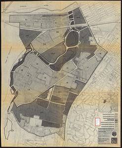
1.
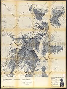
Fenway urban renewal area : major thoroughfares
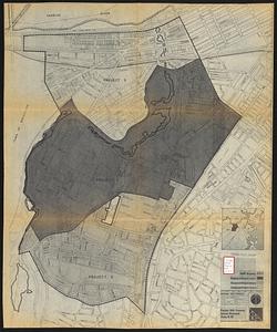
2.
Fenway urban renewal area : blighted areas
3.
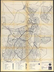
Fenway urban renewal area : locality map
4.
Fenway urban renewal area : existing land use
5.
Fenway urban renewal area : building conditions
6.
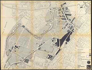
Parker Hill-Fenway urban renewal area r-48 : building conditions
7.
Parker Hill-Fenway urban renewal area r-48 : existing population density
8.
Parker Hill-Fenway urban renewal area r-48 : existing building coverage
9.
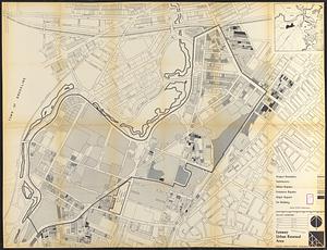
Parker Hill-Fenway urban renewal area r-48 : existing and proposed community facilities
10.
Parker Hill-Fenway urban renewal area r-48 : proposed circulation
11.
Parker Hill-Fenway urban renewal area r-48 : existing institutions
12.
Parker Hill-Fenway urban renewal area r-48 : existing circulation
13.
Parker Hill-Fenway urban renewal area r-48 : proposed land use
14.
Parker Hill-Fenway urban renewal area r-48 : existing land use
15.
Parker Hill-Fenway urban renewal area r-48 : development areas
16.
Parker Hill-Fenway urban renewal area r-48 : proposed title I projects
17.
Back Bay Fens master plan
18.
The Riverway master plan
19.
Fenway urban renewal area Massachusetts : disposition parcels
20.
Fenway urban renewal area Massachusetts : disposition parcels
+
-
Redo search here
Search when I move the map
Leaflet
| ©
OpenStreetMap
contributors, ©
CartoDB
‹ Prev
Next ›
1
2
3
4
5
…
20
21