Toggle navigation
LMEC Home
Exhibitions
Georeferencing
Tools for Teachers
Collections
My Favorites
Sign Up / Log In
Search
Search the map portal
Map Collection
Map Collection
Map Sets
Search
Search
Search for
Search In
All Fields
Creator
Title
Subject
Place
Search All Digital Collections
Advanced Search
3 Results
My Search
Start Over
More Like
commonwealth:6395x8434
Remove constraint More Like: commonwealth:6395x8434
Creator
Faden, William, 1749-1836
Remove constraint Creator: Faden, William, 1749-1836
Filter your Search
Place
New York
2
North and Central America
2
United States
2
Africa
1
Good Hope, Cape of
1
Long Island
1
Manhattan Island
1
New Jersey
1
more
Place
»
Date
Date range begin
–
Date range end
Current results range from
1776
to
1825
1776 : 1826
1776
1826
View distribution
Creator
Faden, William, 1749-1836
[remove]
3
Delarochette, L. (Louis), 1731-1802
1
Sauthier, Claude Joseph
1
Format
Maps/Atlases
3
Georeferenced
No
3
Collection
Robert E. Diefenbach Map Collection at Phillips Academy
3
Available to use
No known restrictions
3
Search Constraints
Sort by relevance
relevance
title
date (asc)
date (desc)
Number of results to display per page
20 per page
10
per page
20
per page
50
per page
100
per page
View results as:
grid view
map view
Search Results
1.
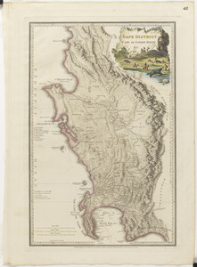
Cape District, Cape of Good Hope
2.
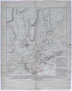
A plan of New York Island, with part of Long Island, Staten Island, & East New York : with a particular description of the...
3.
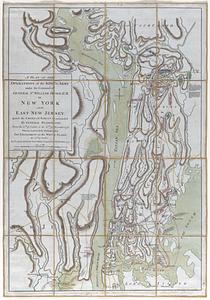
A plan of the operations of the king's army under the command of General Sr. William Howe, K.B. in New York and East New...