Toggle navigation
LMEC Home
Exhibitions
Georeferencing
Tools for Teachers
Collections
My Favorites
Sign Up / Log In
Search
Search the map portal
Map Collection
Map Collection
Map Sets
Search
Search
Search for
Search In
All Fields
Creator
Title
Subject
Place
Search All Digital Collections
Advanced Search
6 Results
My Search
Start Over
More Like
commonwealth-oai:66832281t
Remove constraint More Like: commonwealth-oai:66832281t
Georeferenced
Yes
Remove constraint Georeferenced: Yes
Filter your Search
Place
North and Central America
6
United States
6
Georgia
3
North Carolina
3
South Carolina
2
Alabama
1
Virginia
1
Topic
Georgia--Maps
3
North Carolina--Maps
3
South Carolina--Maps
2
Alabama--Maps
1
Coasts--North Carolina
1
Coasts--South Carolina
1
Counties--Georgia--Maps
1
Counties--North Carolina--Maps
1
more
Topic
»
Date
Date range begin
–
Date range end
Current results range from
1859
to
1894
1859 : 1895
1859
1895
1860
1865
1870
1875
1880
1885
1890
1895
Creator
Lindenkohl, A.
2
United States. Post Office Dept
2
Butts, James R.
1
United States Coast Survey
1
Format
Maps/Atlases
6
Georeferenced
Yes
[remove]
6
Collection
Norman B. Leventhal Map & Education Center Collection
6
Available to use
No known restrictions
6
Search Constraints
Sort by relevance
relevance
title
date (asc)
date (desc)
Number of results to display per page
20 per page
10
per page
20
per page
50
per page
100
per page
View results as:
grid view
map view
Search Results
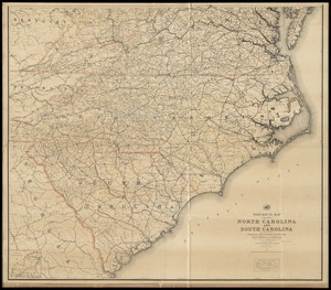
1.
North Carolina & South Carolina
2.
Post route map of the states of North Carolina and South Carolina with adjacent parts of Georgia, Tennessee, Kentucky, West...
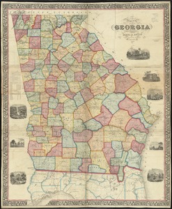
3.
Map of the state of Georgia
4.
Northern Alabama and Georgia
5.
Post route map of the State of Georgia showing post offices with the intermediate distances and mail routes in operation on the...
6.
Middle Virginia and North Carolina
+
-
Redo search here
Search when I move the map
Leaflet
| ©
OpenStreetMap
contributors, ©
CartoDB