Toggle navigation
LMEC Home
Exhibitions
Georeferencing
Tools for Teachers
Collections
My Favorites
Sign Up / Log In
Search
Search the map portal
Map Collection
Map Collection
Map Sets
Search
Search
Search for
Search In
All Fields
Creator
Title
Subject
Place
Search All Digital Collections
Advanced Search
9 Results
My Search
Start Over
More Like
commonwealth:z603vr57s
Remove constraint More Like: commonwealth:z603vr57s
Collection
Urban Maps
Remove constraint Collection: Urban Maps
Filter your Search
Place
North and Central America
9
United States
9
Boston
8
Suffolk (county)
8
Massachusetts
7
Bunker Hill
2
Charlestown
2
Boston Harbor
1
more
Place
»
Topic
Boston (Mass.)--History--Revolution, 1775-1783--Maps--Early works to 1800
8
Fortification--Massachusetts--Boston--Maps--Early works to 1800
5
Boston (Mass.)--Maps--Early works to 1800
2
Bunker Hill, Battle of, Boston, Mass., 1775--Maps--Early works to 1800
2
Boston (Mass.)--History--Siege, 1775-1776--Maps--Early works to 1800
1
Boston Harbor (Mass.)--Maps--Early works to 1800
1
Charlestown (Boston, Mass.)--History--Maps--Early works to 1800
1
Charlestown (Mass.) Boston (Mass.)--History--Revolution, 1775-1783--Maps--Early works to 1800
1
more
Topic
»
Date
Date range begin
–
Date range end
Current results range from
1764
to
1781
1764 : 1782
1764
1782
View distribution
Creator
Page, Thomas Hyde, Sir, 1746-1821
2
Aitken, Robert, 1735-1802
1
Almon, John, 1737-1805
1
Blaskowitz, Charles
1
Dury, Andrew
1
Lattré, Jean
1
Lodge, John, d. 1796
1
Norman, John, 1748?-1817
1
more
Creator
»
Format
Maps/Atlases
9
Georeferenced
Yes
1
No
8
Collection
American Revolutionary War-Era Maps
9
Boston and New England Maps
9
Urban Maps
[remove]
9
Norman B. Leventhal Map & Education Center Collection
7
Mapping Boston Collection
4
Richard H. Brown Revolutionary War Map Collection at Mount Vernon
2
Available to use
Creative Commons license
6
No known restrictions
3
Search Constraints
Sort by relevance
relevance
title
date (asc)
date (desc)
Number of results to display per page
20 per page
10
per page
20
per page
50
per page
100
per page
View results as:
grid view
map view
Search Results
1.
Plan of the town of Boston, with the attack on Bunkers-Hill, in the peninsula of Charlestown, the 17th of June, 1775
2.
Plan of the town of Boston with the attack on Bunkers-Hill in the peninsula of Charlestown the 17th of June 1775
3.
A plan of the town of Boston, with the intrenchments &c. of His Majestys forces in 1775 : from the observations of Lieut. Page...
4.
Map of the environs of Boston
5.
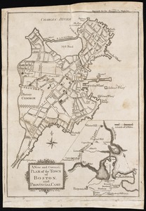
A new and correct plan of the town of Boston
6.
A new and correct plan of the town of Boston, and provincial camp
7.
Plan de la ville et du port de Boston : capitale de la Nouvelle Angleterre : erigée prémierement en 1630, et en 1735 elle fut...
8.
A plan of Boston, and its environs : shewing the true situation of His Majesty's army, and also those of the rebels
9.
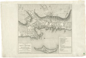
A plan of the town of Newport in Rhode Island
+
-
Redo search here
Search when I move the map
Leaflet
| ©
OpenStreetMap
contributors, ©
CartoDB