Toggle navigation
LMEC Home
Exhibitions
Georeferencing
Tools for Teachers
Collections
My Favorites
Sign Up / Log In
Search
Search the map portal
Map Collection
Map Collection
Map Sets
Search
Search
Search for
Search In
All Fields
Creator
Title
Subject
Place
Search All Digital Collections
Advanced Search
3 Results
My Search
Start Over
More Like
commonwealth:z603vt291
Remove constraint More Like: commonwealth:z603vt291
Collection
Maritime Charts and Atlases
Remove constraint Collection: Maritime Charts and Atlases
Filter your Search
Place
North and Central America
2
Bristol (county)
1
Canada
1
Grand Banks of Newfoundland
1
Halifax Harbour
1
Narragansett Bay
1
Nova Scotia
1
United States
1
Topic
Coasts--Newfoundland and Labrador--Maps--Early works to 1800
1
Grand Banks of Newfoundland--Maps--Early works to 1800
1
Halifax Harbour (N.S.)--Maps--Early works to 1800
1
Halifax, George Montagu-Dunk, Earl of, 1716-1771
1
Narragansett Bay (R.I.)--History--18th century--Maps--Early works to 1800
1
Nautical charts--Newfoundland and Labrador--Early works to 1800
1
Nautical charts--Nova Scotia--Halifax Harbour--Early works to 1800
1
Nautical charts--Rhode Island--Narragansett Bay--Early works to 1800
1
more
Topic
»
Date
Date range begin
–
Date range end
Current results range from
1768
to
1783
1768 : 1784
1768
1784
View distribution
Creator
Blaskowitz, Charles.
1
Jefferys, Thomas, -1771
1
Keulen, Gerard van
1
Morris, Charles
1
Sayer, Robert, 1725-1794
1
Format
Maps/Atlases
3
Georeferenced
No
3
Collection
Maritime Charts and Atlases
[remove]
3
American Revolutionary War-Era Maps
2
Richard H. Brown Revolutionary War Map Collection at Mount Vernon
2
Boston and New England Maps
1
Norman B. Leventhal Map & Education Center Collection
1
Available to use
Creative Commons license
2
No known restrictions
1
Search Constraints
Sort by relevance
relevance
title
date (asc)
date (desc)
Number of results to display per page
20 per page
10
per page
20
per page
50
per page
100
per page
View results as:
grid view
map view
Search Results
1.
A chart of the harbour of Halifax in Nova Scotia : with Jebucto Bay and Cape Sambro also the islands, ledges of rocks, shoals &...
2.
Chart of the Banks of Newfoundland, drawn from a great number of hydrographical surveys, these charts are followed, according...
3.
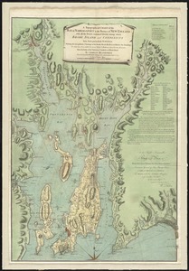
A topographical chart of the bay of Narraganset in the province of New England : with all the isles contained therein, among...
+
-
Redo search here
Search when I move the map
Leaflet
| ©
OpenStreetMap
contributors, ©
CartoDB