Toggle navigation
LMEC Home
Exhibitions
Georeferencing
Tools for Teachers
Collections
My Favorites
Sign Up / Log In
Search
Search the map portal
Map Collection
Map Collection
Map Sets
Search
Search
Search for
Search In
All Fields
Creator
Title
Subject
Place
Search All Digital Collections
Advanced Search
13614 Results
Filter your Search
Place
North and Central America
10,280
United States
8,411
Massachusetts
2,784
Suffolk (county)
1,677
Boston
1,633
Europe
1,413
Canada
950
New York
647
more
Place
»
Topic
Boston (Mass.)--Maps
747
City planning--Massachusetts--Boston--Maps
418
United States--History--Revolution, 1775-1783--Maps
329
United States--Maps
321
Real property--Massachusetts--Boston--Maps
254
Urban renewal--Massachusetts--Boston--Maps
254
Massachusetts--Maps
231
Insurance surveys
197
more
Topic
»
Date
Date range begin
–
Date range end
Current results range from
1482
to
2023
View distribution
Creator
United States. Hydrographic Office
597
Boston Redevelopment Authority
404
Des Barres, Joseph F. W. (Joseph Frederick Wallet), 1722-1824
247
Royal United Services Institute for Defence and Security Studies
160
Jefferys, Thomas, -1771
154
George, III, King of Great Britain, 1738-1820
152
George, IV, King of Great Britain, 1762-1830
151
O.H. Bailey & Co
148
more
Creator
»
Format
Maps/Atlases
13,433
Manuscripts
985
Prints
102
Books
49
Drawings/Illustrations
44
Photographs
15
Objects/Artifacts
13
Documents
7
more
Format
»
Georeferenced
Yes
979
No
12,635
Collection
Norman B. Leventhal Map & Education Center Collection
9,088
American Revolutionary War-Era Maps
3,305
Boston and New England Maps
2,906
Urban Maps
2,465
Maritime Charts and Atlases
1,169
William L. Clements Library Collection
910
Library of Congress Collection
618
Boston Redevelopment Authority Collection
475
more
Collection
»
Available to use
No known restrictions
10,181
Creative Commons license
1,677
Search Constraints
Sort by relevance
relevance
title
date (asc)
date (desc)
Number of results to display per page
20 per page
10
per page
20
per page
50
per page
100
per page
View results as:
grid view
map view
Search Results
221.
Airport obstruction chart OC 136, Enid Woodring Municipal Airport, Enid, Oklahoma
222.
Airport obstruction chart OC 140, Mahlon Sweet Field, Eugene, Oregon
223.
Airport obstruction chart OC 140, Mahlon Sweet Field, Eugene, Oregon
224.
Airport obstruction chart OC 142, Snohomish County (Paine Field) Airport, Everett, Washington
225.
Airport obstruction chart OC 142, Snohomish County (Paine Field) Airport, Everett, Washington
226.
Airport obstruction chart OC 144, Hector International Airport, Fargo, North Dakota
227.
Airport obstruction chart OC 145, Florence Regional Airport, Florence, South Carolina
228.
Airport obstruction chart OC 154, Page Field, Fort Myers, Florida
229.
Airport obstruction chart OC 58, General Edward Lawrence Logan International Airport, Boston, Massachusetts
230.
Airways of the world on Mercator's projection
231.
Aitoff's equal area projection of the sphere
232.
Ajia tōbu yochizu
233.
Alabama
234.
Alas, poor Yorick!--from the painting by Horace Fisher
235.
Alaska and adjoining region
236.
Alaska and adjoining territory
237.
Alaska and adjoining territory
238.
The Alaska Railroad
239.
Albania
240.
Albany, New York : 1879
‹ Prev
Next ›
1
2
…
8
9
10
11
12
13
14
15
16
…
680
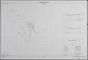
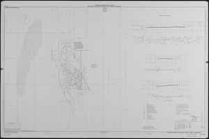
681