Toggle navigation
LMEC Home
Exhibitions
Georeferencing
Tools for Teachers
Collections
My Favorites
Sign Up / Log In
Search
Search the map portal
Map Collection
Map Collection
Map Sets
Search
Search
Search for
Search In
All Fields
Creator
Title
Subject
Place
Search All Digital Collections
Advanced Search
13518 Results
Filter your Search
Place
North and Central America
10,232
United States
8,367
Massachusetts
2,778
Suffolk (county)
1,675
Boston
1,631
Europe
1,386
Canada
949
New York
640
more
Place
»
Topic
Boston (Mass.)--Maps
746
City planning--Massachusetts--Boston--Maps
418
United States--History--Revolution, 1775-1783--Maps
329
United States--Maps
321
Real property--Massachusetts--Boston--Maps
254
Urban renewal--Massachusetts--Boston--Maps
254
Massachusetts--Maps
230
Insurance surveys
197
more
Topic
»
Date
Date range begin
–
Date range end
Current results range from
1482
to
2023
View distribution
Creator
United States. Hydrographic Office
596
Boston Redevelopment Authority
404
Des Barres, Joseph F. W. (Joseph Frederick Wallet), 1722-1824
247
Royal United Services Institute for Defence and Security Studies
160
Jefferys, Thomas, -1771
154
George, III, King of Great Britain, 1738-1820
152
George, IV, King of Great Britain, 1762-1830
151
O.H. Bailey & Co
148
more
Creator
»
Format
Maps/Atlases
13,337
Manuscripts
985
Prints
102
Books
49
Drawings/Illustrations
44
Photographs
15
Objects/Artifacts
13
Documents
7
more
Format
»
Georeferenced
Yes
979
No
12,539
Collection
Norman B. Leventhal Map & Education Center Collection
9,022
American Revolutionary War-Era Maps
3,305
Boston and New England Maps
2,900
Urban Maps
2,425
Maritime Charts and Atlases
1,167
William L. Clements Library Collection
910
Library of Congress Collection
618
Boston Redevelopment Authority Collection
475
more
Collection
»
Available to use
No known restrictions
10,085
Creative Commons license
1,677
Search Constraints
Sort by relevance
relevance
title
date (asc)
date (desc)
Number of results to display per page
20 per page
10
per page
20
per page
50
per page
100
per page
View results as:
grid view
map view
Search Results
5721.
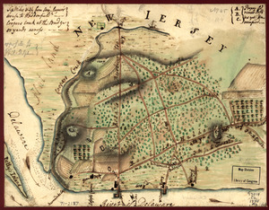
Map of the environs of Camden, N.J
5722.
[Map of the environs of Quebec showing the position of the English and French troops]
5723.
Map of the environs of Roxbury showing roads to Jamaica, Cambridge, Dorchester, Milton, etc
5724.
Map of the environs of the City of Mexico : authorized for publication with the Mexican guide
5725.
Map of the estate of the Brookline Land Company and vicinity : showing especially the relation of this property to the park...
5726.
Map of the European & North American Railway and its connections
5727.
Map of the European and North American Railway, showing its connection with the railways of the United States & Canada; made by...
5728.
Map of the European settlements in North America
5729.
Map of the European settlements in North America
5730.
Map of the European settlements in South America and on the western coast of Africa
5731.
Map of the European settlements in the East Indies and on the eastern coast of Africa including part of Europe
5732.
Map of the European settlements in the West Indies
5733.
Map of the existing and proposed circumferential thoroughfares of the district
5734.
Map of the existing and proposed radial thoroughfares of the district and their connections
5735.
A map of the extremity of Cape Cod : including the townships of Provincetown & Truro: with chart of their sea coast and of Cape...
5736.
A map of the farm and a draught of the buildings thereon, in West-town Township, Chester Co. Pennsylvania, belonging to the...
5737.
A map of the farm of Wm. Wilson esqr. in Clermont ... : surveyed May 3d, 1799
5738.
Map of the field of Shiloh, near Pittsburgh Landing, Tenn., shewing the positions of the U.S. forces under the command of Maj....
5739.
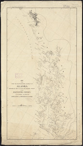
Map of the first or Southeastern district of Alaska
5740.
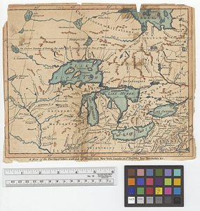
A map of the five Great Lakes with part of Pensilvania, New York, Canada and Hudsons Bay territories &c.
‹ Prev
Next ›
1
2
…
283
284
285
286
287
288
289
290
291
…
675
676
![[Map of the environs of Quebec showing the position of the English and French troops]](https://bpldcassets.blob.core.windows.net/derivatives/images/commonwealth:hx11xz690/image_thumbnail_300.jpg)