Toggle navigation
LMEC Home
Exhibitions
Georeferencing
Tools for Teachers
Collections
My Favorites
Sign Up / Log In
Search
Search the map portal
Map Collection
Map Collection
Map Sets
Search
Search
Search for
Search In
All Fields
Creator
Title
Subject
Place
Search All Digital Collections
Advanced Search
2843 Results
My Search
Start Over
atlas
Remove constraint atlas
Filter your Search
Place
North and Central America
1,647
United States
987
Europe
464
Massachusetts
348
Canada
271
Asia
190
South America
189
Suffolk (county)
163
more
Place
»
Topic
Landowners--Massachusetts--Boston--Maps
115
Real property--Massachusetts--Boston--Maps
106
United States--Maps
87
Boston (Mass.)--Maps
63
United States--History--French and Indian War, 1754-1763--Maps
63
Saint Lawrence River--Maps
41
Nautical charts--Early works to 1800
39
North America--Maps--Early works to 1800
36
more
Topic
»
Date
Date range begin
–
Date range end
Current results range from
1482
to
2023
View distribution
Creator
United States. Hydrographic Office
582
Des Barres, Joseph F. W. (Joseph Frederick Wallet), 1722-1824
118
Ptolemy, 2nd cent
100
Bromley, George Washington
99
Bromley, Walter Scott
97
G.W. Bromley & Co.
75
Carey, Mathew, 1760-1839
74
Paullin, Charles Oscar, 1868 or 1869-1944
70
more
Creator
»
Format
Maps/Atlases
2,827
Manuscripts
58
Books
37
Prints
8
Documents
5
Drawings/Illustrations
1
Georeferenced
Yes
142
No
2,701
Collection
Norman B. Leventhal Map & Education Center Collection
2,386
Maritime Charts and Atlases
1,150
American Revolutionary War-Era Maps
504
Boston and New England Maps
374
Urban Maps
250
Massachusetts Real Estate Atlases
144
William L. Clements Library Collection
92
Mapping Boston Collection
61
more
Collection
»
Available to use
No known restrictions
2,292
Creative Commons license
158
Search Constraints
Sort by relevance
relevance
title
date (asc)
date (desc)
Number of results to display per page
20 per page
10
per page
20
per page
50
per page
100
per page
View results as:
grid view
map view
Search Results
1301.
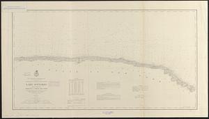
Lake Ontario
1302.
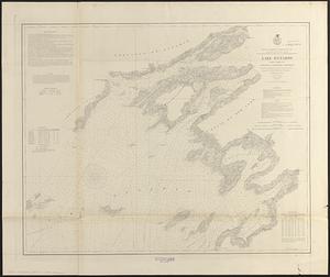
Lake Ontario
1303.
Lake Ontario
1304.
Lake Ontario
1305.
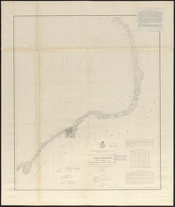
Lake Superior : chart no. 1
1306.
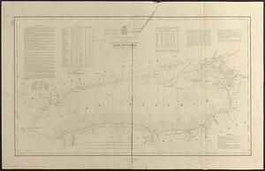
Lake Superior : chart no. 3
1307.
Lake Superior : chart no. 2
1308.
A large draft of the island Antegua
1309.
Loo Choo Id., Deep Bay
1310.
(Loo Choo) Tubootch & Suco Harbors
1311.
Low Archipelago or Paumotu Group
1312.
Madagascar--n.w. coast, Bavatoubé Bay (Dalrymple Bay)
1313.
Madeira, Porto Santo and Dezertas : from British surveys in 1843, corrected to 1871
1314.
Makatea or Aurora Island, Paumotu Group ; Taweree or St. Simeon or Resolution Island, Paumotu Group ; Takurea or Wolconsky...
1315.
Map of Merrimack County, New Hampshire
1316.
Map of New-York Bay and Harbor and the environs
1317.
A map of the isle of Cuba : with the Bahama Islands, Gulf of Florida, and Windward Passage ; drawn from English and Spanish...
1318.
Mare del Nord
1319.
Mare del Svd, detto altrimenti Mare Pacifico
1320.
M'bua or Sandalwood Bay, Island of Vanua Levu, Feejee Group
‹ Prev
Next ›
1
2
…
62
63
64
65
66
67
68
69
70
…
142
143