Toggle navigation
LMEC Home
Exhibitions
Georeferencing
Tools for Teachers
Collections
My Favorites
Sign Up / Log In
Search
Search the map portal
Map Collection
Map Collection
Map Sets
Search
Search
Search for
Search In
All Fields
Creator
Title
Subject
Place
Search All Digital Collections
Advanced Search
13518 Results
Filter your Search
Place
North and Central America
10,232
United States
8,367
Massachusetts
2,778
Suffolk (county)
1,675
Boston
1,631
Europe
1,386
Canada
949
New York
640
more
Place
»
Topic
Boston (Mass.)--Maps
746
City planning--Massachusetts--Boston--Maps
418
United States--History--Revolution, 1775-1783--Maps
329
United States--Maps
321
Real property--Massachusetts--Boston--Maps
254
Urban renewal--Massachusetts--Boston--Maps
254
Massachusetts--Maps
230
Insurance surveys
197
more
Topic
»
Date
Date range begin
–
Date range end
Current results range from
1482
to
2023
View distribution
Creator
United States. Hydrographic Office
596
Boston Redevelopment Authority
404
Des Barres, Joseph F. W. (Joseph Frederick Wallet), 1722-1824
247
Royal United Services Institute for Defence and Security Studies
160
Jefferys, Thomas, -1771
154
George, III, King of Great Britain, 1738-1820
152
George, IV, King of Great Britain, 1762-1830
151
O.H. Bailey & Co
148
more
Creator
»
Format
Maps/Atlases
13,337
Manuscripts
985
Prints
102
Books
49
Drawings/Illustrations
44
Photographs
15
Objects/Artifacts
13
Documents
7
more
Format
»
Georeferenced
Yes
979
No
12,539
Collection
Norman B. Leventhal Map & Education Center Collection
9,022
American Revolutionary War-Era Maps
3,305
Boston and New England Maps
2,900
Urban Maps
2,425
Maritime Charts and Atlases
1,167
William L. Clements Library Collection
910
Library of Congress Collection
618
Boston Redevelopment Authority Collection
475
more
Collection
»
Available to use
No known restrictions
10,085
Creative Commons license
1,677
Search Constraints
Sort by relevance
relevance
title
date (asc)
date (desc)
Number of results to display per page
20 per page
10
per page
20
per page
50
per page
100
per page
View results as:
grid view
map view
Search Results
981.
Bedford irrigation farm
982.
Begin with sense, of ev'ry art the soul, parts answ'ring parts shall slide into a whole
983.
The beginnings of ancient China, 1900-1300 B.C.
984.
Behring's Sea and Arctic Ocean : from surveys of the U.S. North Pacific Surveying Expedition in 1855, Commander John Rodgers,...
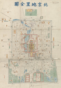
985.
Beijing dili quantu
986.
Being a cartograph of Ohio : the oldest state west of the thirteen original colonies; now the fourth state in the Union in...
987.
Being a map of the United States in the year 1831 when the Country Gentleman first made its appearance as the Genesee Farmer
988.
Belgii Novi, Angliae Novae, et partis Virginiae : novissima delineatio
989.
Belgii veteris typus
990.
Bellovaci et Silvanectes : les Eveschés de Beauvais et Senlis : Comté et Pairrie de Beauvais : Les Balliages de Beauvais,...
991.
Bellows Falls, Vt
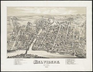
992.
Belvidere : New Jersey
993.
Belvidere Park : Lowell, Mass
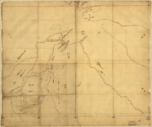
994.
Bend of the Missouri River
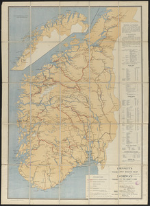
995.
Bennett's tourists' route map of Norway
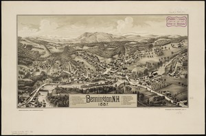
996.
Bennington, N.H : 1887
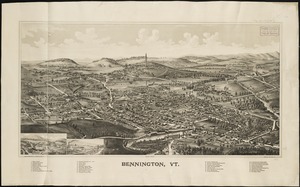
997.
Bennington, Vt : [1887]
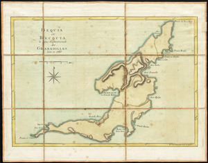
998.
Bequia ou Becouya, le plus septentrionale des Granadilles : levé en 1763
999.
Berkeley Street community garden
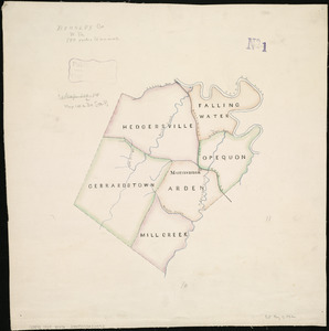
1000.
Berkley Co., W. Va
‹ Prev
Next ›
1
2
…
46
47
48
49
50
51
52
53
54
…
675
676