Toggle navigation
LMEC Home
Exhibitions
Georeferencing
Tools for Teachers
Collections
My Favorites
Sign Up / Log In
Search
Search the map portal
Map Collection
Map Collection
Map Sets
Search
Search
Search for
Search In
All Fields
Creator
Title
Subject
Place
Search All Digital Collections
Advanced Search
13674 Results
Filter your Search
Place
North and Central America
10,340
United States
8,471
Massachusetts
2,787
Suffolk (county)
1,677
Boston
1,633
Europe
1,413
Canada
950
New York
649
more
Place
»
Topic
Boston (Mass.)--Maps
747
City planning--Massachusetts--Boston--Maps
418
United States--History--Revolution, 1775-1783--Maps
329
United States--Maps
321
Real property--Massachusetts--Boston--Maps
254
Urban renewal--Massachusetts--Boston--Maps
254
Massachusetts--Maps
231
Insurance surveys
197
more
Topic
»
Date
Date range begin
–
Date range end
Current results range from
1482
to
2023
View distribution
Creator
United States. Hydrographic Office
597
Boston Redevelopment Authority
404
Des Barres, Joseph F. W. (Joseph Frederick Wallet), 1722-1824
247
Royal United Services Institute for Defence and Security Studies
160
Jefferys, Thomas, -1771
154
George, III, King of Great Britain, 1738-1820
152
George, IV, King of Great Britain, 1762-1830
151
O.H. Bailey & Co
148
more
Creator
»
Format
Maps/Atlases
13,493
Manuscripts
985
Prints
102
Books
49
Drawings/Illustrations
44
Photographs
15
Objects/Artifacts
13
Documents
7
more
Format
»
Georeferenced
Yes
979
No
12,695
Collection
Norman B. Leventhal Map & Education Center Collection
9,091
American Revolutionary War-Era Maps
3,305
Boston and New England Maps
2,913
Urban Maps
2,468
Maritime Charts and Atlases
1,169
William L. Clements Library Collection
910
Library of Congress Collection
618
Boston Redevelopment Authority Collection
475
more
Collection
»
Available to use
No known restrictions
10,241
Creative Commons license
1,677
Search Constraints
Sort by relevance
relevance
title
date (asc)
date (desc)
Number of results to display per page
20 per page
10
per page
20
per page
50
per page
100
per page
View results as:
grid view
map view
Search Results
2381.
China, south coast, principal ethnic groups and dialects
2382.
China's situation in the world
2383.
[Chippewa] National Forest, Minnesota
2384.
A chorographical map of the country round Philadelphia = Carte particuliere des environs de Philadelphia
2385.
A chorographical map, of the country, round Philadelphia = : carte particuliere, des environs de Philadelphie
2386.
A chorographical map of the northern department of North-America : drawn from the latest and most accurate observations
2387.
A chorographical map of the northern department of North-America
2388.
A chorographical map of the Province of New-York in North America, divided into counties, manors, patents and townships :...
2389.
A chorographical map of the Province of New-York in North America, divided into counties, manors, patents and townships :...
2390.
A chorographical map of the Province of New-York in North America, divided into counties, manors, patents and townships :...
2391.
Choro-topographische kaart der Noordelijke provincien van het Koningrijk der Nederlanden
2392.
Chūseki keishi chizu
2393.
A cidade de Angra na ilha de Iesu xpō da Tercera que esta em 39. graos
2394.
Circolo di Svevia diviso ne suoi stati di nuova projezione
2395.
Circular world map
2396.
Circulation plan of parking lot at the corner of VFW Parkway and Spring Street, West Roxbury
2397.
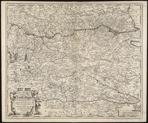
Circuli Austriaci pars septentrionalis in qua Archiducatus Austriae et Ducatus Stiriae accuratissime divisi ostenduntur
2398.
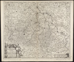
Circuli Saxoniae superioris pars meridionalis in qua sunt ducatus Saxoniae, comitatus Mansfeldiae, et Voitlandiae, landgraviat...
2399.
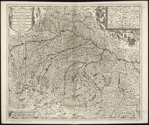
Circulus Bavaricus in quo sunt Ducatus, Electoratus, & Palatinat Bavariae, Archiepisc: Salisburgi, Episcopatus Ratisbonaw,...
2400.
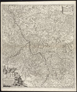
Circulus electorum Rheni sive Rhenanus Inferior complectens accuratam descriptionem Archiepiscopatus Moguntini Coloniensis et...
‹ Prev
Next ›
1
2
…
116
117
118
119
120
121
122
123
124
…
683
684


![[Chippewa] National Forest, Minnesota](https://bpldcassets.blob.core.windows.net/derivatives/images/commonwealth:th83pg40d/image_thumbnail_300.jpg)