Search Constraints
Search Results
![Wamsutta Mills (Cotton Mill), New Bedford, Mass. [insurance map]](https://bpldcassets.blob.core.windows.net/derivatives/images/commonwealth:ww72bz961/image_thumbnail_300.jpg)
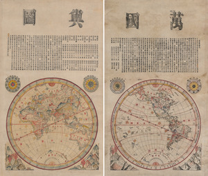
13022. Wanguo yutu
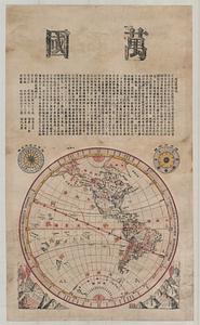
13023. Wanguo yutu


13028. War maps and diagrams


13030. War telegram marking map
![Ward 1 [of Boston]](https://bpldcassets.blob.core.windows.net/derivatives/images/commonwealth:jh343z28f/image_thumbnail_300.jpg)
13031. Ward 1 [of Boston]

13032. Ward boundaries 1959


13035. Wards & precincts


13037. Warner, N.H : 1887

13038. Warren

