Toggle navigation
LMEC Home
Exhibitions
Georeferencing
Tools for Teachers
Collections
My Favorites
Sign Up / Log In
Search
Search the map portal
Map Collection
Map Collection
Map Sets
Search
Search
Search for
Search In
All Fields
Creator
Title
Subject
Place
Search All Digital Collections
Advanced Search
10836 Results
My Search
Start Over
All Fields
americas
Remove constraint All Fields: americas
Filter your Search
Place
North and Central America
10,232
United States
8,361
Massachusetts
2,778
Suffolk (county)
1,673
Boston
1,629
Canada
936
New York
640
Middlesex (county)
438
more
Place
»
Topic
Boston (Mass.)--Maps
745
City planning--Massachusetts--Boston--Maps
418
United States--History--Revolution, 1775-1783--Maps
327
United States--Maps
319
Real property--Massachusetts--Boston--Maps
254
Urban renewal--Massachusetts--Boston--Maps
254
Massachusetts--Maps
230
Insurance surveys
194
more
Topic
»
Date
Date range begin
–
Date range end
Current results range from
1507
to
2023
View distribution
Creator
Boston Redevelopment Authority
404
United States. Hydrographic Office
365
Des Barres, Joseph F. W. (Joseph Frederick Wallet), 1722-1824
197
Jefferys, Thomas, -1771
150
George, III, King of Great Britain, 1738-1820
146
O.H. Bailey & Co
146
George, IV, King of Great Britain, 1762-1830
145
Royal United Services Institute for Defence and Security Studies
139
more
Creator
»
Format
Maps/Atlases
10,713
Manuscripts
916
Prints
60
Books
43
Drawings/Illustrations
43
Photographs
15
Objects/Artifacts
7
Posters
3
more
Format
»
Georeferenced
Yes
823
No
10,013
Collection
Norman B. Leventhal Map & Education Center Collection
6,600
American Revolutionary War-Era Maps
3,123
Boston and New England Maps
2,897
Urban Maps
2,277
William L. Clements Library Collection
892
Maritime Charts and Atlases
814
Library of Congress Collection
552
Boston Redevelopment Authority Collection
475
more
Collection
»
Available to use
No known restrictions
7,653
Creative Commons license
1,540
Search Constraints
Sort by relevance
relevance
title
date (asc)
date (desc)
Number of results to display per page
20 per page
10
per page
20
per page
50
per page
100
per page
View results as:
grid view
map view
Search Results
1761.
A map of Canada and the north part of Louisiana with the adjacent countrys
1762.
Plan of the town and fort of Grenada
1763.
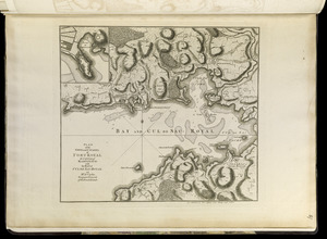
Plan of the town and citadel of Fort Royal, the capital of Martinico : with the Bay of Cul de Sac Royal
1764.
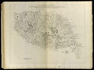
Plan de l'isle de la Grenade : ou sont marqués dans leur juste position, les ports et mouillages, les ville et bourgs, les...
1765.
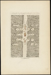
A plan of the line of march of the detachment from the little Meadows
1766.
A map of the country between Will's Creek & Monongahela River shewing the rout and encampments of the English army in 1755
1767.
An authentic plan of the town and harbour of Cap-François in the isle of St. Domingo
1768.
Plan of the city of San Domingo
1769.
The State of Rhode Island, : from the latest surveys. 1796
1770.
Plan of Boston
1771.
An accurate map of His Majesty's province of New-Hampshire in New England : taken from actual surveys of all the inhabited...
1772.
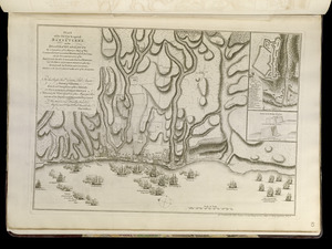
A plan of the field of battle and disposition of the troops, as they were on the march at the time of the attack on the 9th of...
1773.
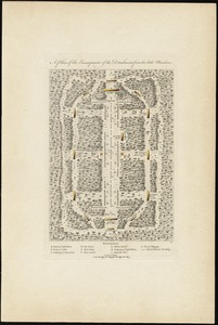
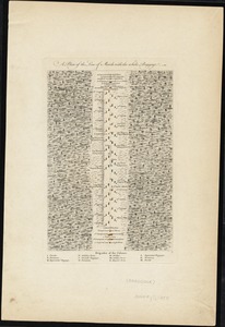
A plan of the encampment of the detachment from the little Meadows
1774.
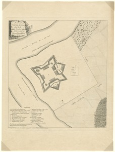
Plan of Fort le Quesne, built by the French at the fork of the Ohio and Monongahela in 1754
1775.
A plan of the line of march of the detachment from the little Meadows
1776.
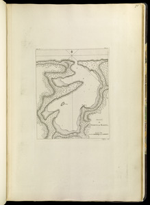
Plan de Puerto de Mariel
1777.
A plan of the line of march with the whole baggage
1778.
Plan of the attack against Basseterre on the island of Guadeloupe by a squadron of his Majesty's ships of war commanded by...
1779.
Plan of the attack against Fort Louis now Fort George, at Point à Pitre on the island of Guadaloupe : by a squadron of His...
1780.
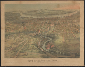
City of Hartford, Conn.
‹ Prev
Next ›
1
2
…
85
86
87
88
89
90
91
92
93
…
541
542