Toggle navigation
LMEC Home
Exhibitions
Georeferencing
Tools for Teachers
Collections
My Favorites
Sign Up / Log In
Search
Search the map portal
Map Collection
Map Collection
Map Sets
Search
Search
Search for
Search In
All Fields
Creator
Title
Subject
Place
Search All Digital Collections
Advanced Search
10961 Results
My Search
Start Over
All Fields
americas
Remove constraint All Fields: americas
Filter your Search
Place
North and Central America
10,354
United States
8,478
Massachusetts
2,796
Suffolk (county)
1,676
Boston
1,632
Canada
937
New York
650
Middlesex (county)
441
more
Place
»
Topic
Boston (Mass.)--Maps
747
City planning--Massachusetts--Boston--Maps
418
United States--History--Revolution, 1775-1783--Maps
327
United States--Maps
320
Real property--Massachusetts--Boston--Maps
254
Urban renewal--Massachusetts--Boston--Maps
254
Massachusetts--Maps
233
Insurance surveys
194
more
Topic
»
Date
Date range begin
–
Date range end
Current results range from
1507
to
2023
View distribution
Creator
Boston Redevelopment Authority
404
United States. Hydrographic Office
366
Des Barres, Joseph F. W. (Joseph Frederick Wallet), 1722-1824
197
Jefferys, Thomas, -1771
150
George, III, King of Great Britain, 1738-1820
146
O.H. Bailey & Co
146
George, IV, King of Great Britain, 1762-1830
145
Royal United Services Institute for Defence and Security Studies
139
more
Creator
»
Format
Maps/Atlases
10,838
Manuscripts
916
Prints
60
Books
43
Drawings/Illustrations
43
Photographs
15
Objects/Artifacts
7
Posters
3
more
Format
»
Georeferenced
Yes
823
No
10,138
Collection
Norman B. Leventhal Map & Education Center Collection
6,635
American Revolutionary War-Era Maps
3,123
Boston and New England Maps
2,918
Urban Maps
2,294
William L. Clements Library Collection
892
Maritime Charts and Atlases
816
Library of Congress Collection
552
Boston Redevelopment Authority Collection
475
more
Collection
»
Available to use
No known restrictions
7,777
Creative Commons license
1,541
Search Constraints
Sort by relevance
relevance
title
date (asc)
date (desc)
Number of results to display per page
20 per page
10
per page
20
per page
50
per page
100
per page
View results as:
grid view
map view
Search Results
10661.
A new chart of the Gulf of Florida and Bahama Banks also the Bahama Islands taken from a new chart published in Cadiz from a...
10662.
New Found Land, St. Laurence Bay, the fishing banks, Acadia, and part of New Scotland
10663.
New France, New Englande, New Scotlande, and New Foundlande
10664.
A new map of Nova Scotia and Cape Breton Island : with the adjacent parts of New England and Canada composed from a great...
10665.
Nieuwe en aldereerste afteekening van 't eyland St. Thomas : met alle desselfs havenen, anker plaatse en geleegentheden is...
10666.
The north coast of the Gulf of Mexico, from St. Marks to Galveston
10667.
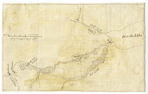
Oneida Lake to the Mohawk River
10668.
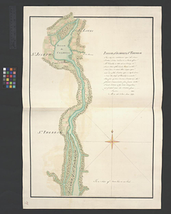
Parish of Chambly & Ste. Therese
10669.
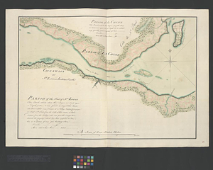
Parish of La Chine. Parish of the Saut of St. Louis. Cocnawaga or St. Louis Indian Castle
10670.
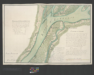
Parish of La Norray & Dautray. Parish of Sorrel
10671.
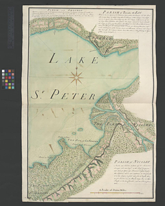
Parish of Omchis. Parish of Pointe du Lac. Parish of Nicolet
10672.
Parish of St. Charles
10673.
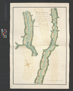
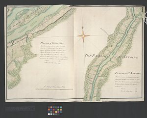
Parish of Vercheres. Parish of St. Antoine
10674.
Perspective view of Bunker Hill Monument
10675.
Plan and sections of Fort Fisher, carried by assault by the U.S. forces, Maj. Gen. A.H. Terry commanding, Jan. 15th, 1865
10676.
Plan du fort de Carillon et de ses environs avec l'attaque des retranchments faite par une armee Angloise de 25000 homes aux...
10677.
Plan of Amelia Island in East Florida : A chart of the entrance into St. Mary's River taken by Captn. W. Fuller in November,...
10678.
[Plan of boundary lines in Roxbury and the City of Boston]
10679.
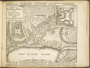
A plan of Fort William Henry and the English camps & retrenchments with the French different camps and attack there upon
10680.
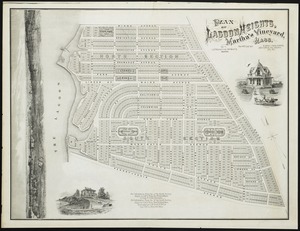
Plan of Lagoon Heights, Martha's Vineyard, Mass
‹ Prev
Next ›
1
2
…
530
531
532
533
534
535
536
537
538
…
548
549


![[Plan of boundary lines in Roxbury and the City of Boston]](https://bpldcassets.blob.core.windows.net/derivatives/images/commonwealth:1257bb127/image_thumbnail_300.jpg)