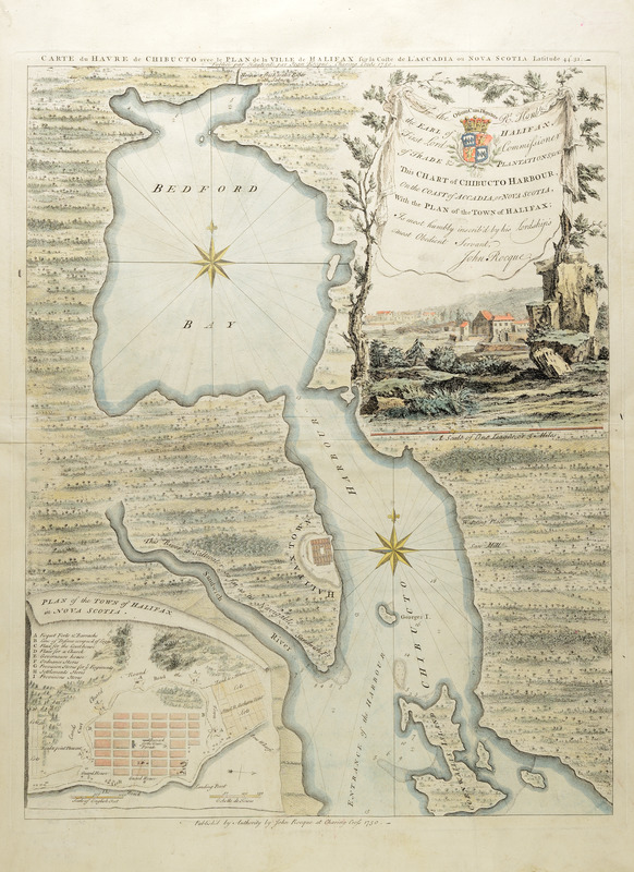
Carte du havre de Chibucto avec le plan de la ville de Halifax sur la coste de l'Accadia ou Nova Scotia latitude 44° 31ʹ
This map is also available in American Revolutionary Geographies Online (ARGO), a collections portal especially built for material relating to the American Revolutionary War Era. Visit ARGO to learn more about this item and explore the historical geography of North America in the late eighteenth century.
Item Information
- Title:
- Carte du havre de Chibucto avec le plan de la ville de Halifax sur la coste de l'Accadia ou Nova Scotia latitude 44° 31ʹ
- Publisher:
- Rocque, John, -1762
- Dedicatee:
- Halifax, George Montagu-Dunk, Earl of, 1716-1771
- Date:
-
1750
- Format:
-
Maps/Atlases
- Location:
- Boston Athenaeum
- Collection (local):
-
Cartographic Collection
- Subjects:
-
Halifax (N.S.)--Pictorial works
Halifax (N.S.)--Maps--Early works to 1800
Acadia--Maps--Early works to 1800
Bedford Bay (N.S.)--Maps--Early works to 1800
Halifax Harbour (N.S.)--Maps--Early works to 1800
- Places:
-
CanadaHalifax Harbour (harbor)
CanadaHalifax
Bedford Bay
- Extent:
- 1 map : col. 56 x 44 cm., sheet 69 x 52 cm.
- Terms of Use:
-
No known copyright restrictions.
This work is licensed for use under a Creative Commons Attribution Non-Commercial Share Alike License (CC BY-NC-SA).

- Publisher:
-
[London] :
Publiée par hautorité par Jean Rocque, Charing Cross
- Scale:
-
Scale [ca. 1:27:400]
- Language:
-
English
- Catalog Record:
-
http://catalog.bostonathenaeum.org/vwebv/holdingsInfo?bibId=505520
- Notes:
-
Depths shown by soundings, contours and shading.
Hand-colored.
"Publish'd by authority of John Rocque at Charing Cross, 1750"--Lower margin of map.
Dedication in cartouche: "To the Rt. Honble. the Earl of Halifax, First Lord Commissioner of trade & plantations &c. &c. This chart of Chibucto Harbour, on the coast of Accadia, or Nova Scotia, with the plan of the town of Halifax; is most humbly inscrib'd by his Lordship's most obedient servant, John Rocque." View of buildings and a mill, presumably the new town of Halifax.
Inset at lower left: Plan of the town of Halifax in Nova Scotia.
Engraved map.
In French and English.