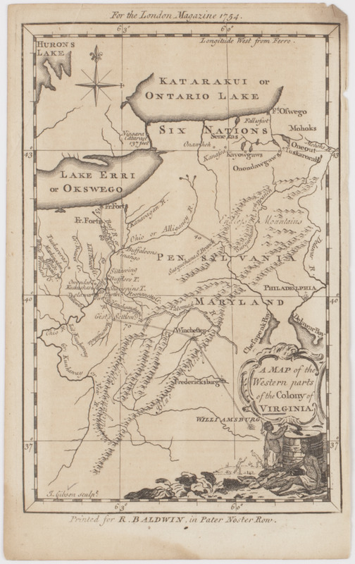
A Map of the western parts of the colony of Virginia
This map is also available in American Revolutionary Geographies Online (ARGO), a collections portal especially built for material relating to the American Revolutionary War Era. Visit ARGO to learn more about this item and explore the historical geography of North America in the late eighteenth century.
Item Information
- Title:
- A Map of the western parts of the colony of Virginia
- Title (uniform):
-
London magazine
- Description:
-
Subject: Map of the parts of the Virginia territory stretching into present day Ohio. A cartouche at lower right shows two Native Americans beside a large barrel.
- Publisher:
- Baldwin, R. (Robert), 1737-1810
- Engraver:
- Gibson, J. (John), active 1750-1792
- Name on Item:
-
J. Gibson sculpt.
- Date:
-
[1754]
- Format:
-
Maps/Atlases
- Location:
- American Antiquarian Society
- Collection (local):
-
American Antiquarian Society Collection
- Subjects:
-
Indians of North America--Pictorial works
Virginia--Maps
- Places:
-
Virginia
- Extent:
- 1 map : engraving ; 19 x 13 cm., on sheet 22 x 13 cm.
- Terms of Use:
-
Public Domain/No known restrictions on use. Contact host institution to download image.
Contact host institution for more information.
- Publisher:
-
[London] :
Printed for R. Baldwin, in Pater Noster Row.
- Scale:
-
Scale not given
- Language:
-
English
- Catalog Record:
-
http://catalog.mwa.org/vwebv/holdingsInfo?bibId=488847
- Notes:
-
Prime meridian: Ferro.
Relief shown pictorially.
"For the London magazine 1754."
- Notes (date):
-
This date is inferred.


