Complete map of the rail roads and water courses in the United States & Canada
Item Information
- Title:
- Complete map of the rail roads and water courses in the United States & Canada
- Description:
-
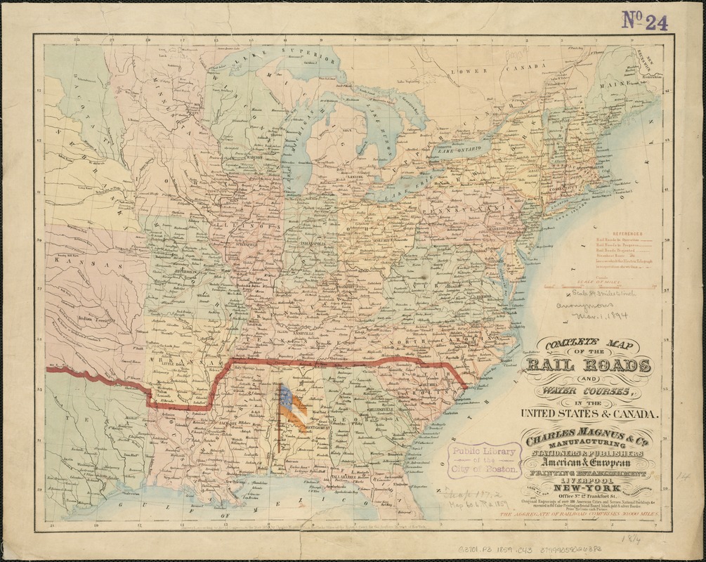
Torn in Two: As sectional tensions increased during the late 1850s, there was rising sentiment among the southern states advocating secession. However, the spark that ignited the secessionist movement was Republican Abraham Lincoln’s victory in the Presidential 1860 election. Fearing the loss of their rights as slaveholders, seven states seceded and formed the Confederate States of America with Jefferson Davis as President. Originally published in 1859, this rare railroad map was overprinted to show the first states to secede. The initial boundary of the Confederacy is marked by a heavy red line. Also depicted is the first flag of the Confederate States of America, the Stars and Bars. It was placed over the state of Alabama, signifying Montgomery as the first capital of the Confederacy.
America Transformed: This map displays the nation's growing transportation and communication network on the eve of the Civil War. The legend identifies rail lines that were in operation, in progress, and proposed, along with telegraph and coastal steamship lines. Railroads were densest in the North, extending from New England through the Mid-Atlantic and Midwestern states. In the South, the network was less dense, with shorter lines running from interior locations to coastal ports. This map was overprinted around 1861 to show the first southern states to secede from the Union with an early version of the Confederate flag flying over Montgomery, Alabama, the first capital of the Confederacy.
- Creator:
- Charles Magnus & Co
- Date:
-
[1859]
- Format:
-
Maps/Atlases
- Location:
-
Boston Public Library
Norman B. Leventhal Map & Education Center - Collection (local):
-
Norman B. Leventhal Map & Education Center Collection
- Subjects:
-
Railroads--United States--Maps
Railroads--Canada--Maps
Waterways--United States--Maps
Waterways--Canada--Maps
Telegraph lines--United States--Maps
Telegraph lines--Canada--Maps
United States--Maps
- Places:
-
United States
Canada
- Extent:
- 1 map : hand col. ; 36 x 47 cm.
- Terms of Use:
-
No known copyright restrictions.
No known restrictions on use.
- Publisher:
-
New York :
Charles Magnus & Co.
- Scale:
-
Scale [ca. 1:5,800,000].
- Language:
-
English
- Notes:
-
Also shows electric telegraph lines in operation.
Shows only a portion of southern Canada.
Shows wood block print of the first national Confederate flag overprinted on map and marks the boundary of the early Confederate states.
"Entered according to act of Congress, in the year 1859, by Charles Magnus & Co. ..."
- Notes (date):
-
This date is inferred.
- Notes (exhibitions):
-
Exhibited: "Torn in Two: The 150th Anniversary of the Civil War," organized by the Norman B. Leventhal Map Center at the Boston Public Library, 2011.
Exhibited: "America transformed. Part 1: the United States expands westward," organized by the Norman B. Leventhal Map & Education Center at the Boston Public Library, 2019.
- Identifier:
-
06_01_006531
- Call #:
-
G3701.P3 1859 .C43
- Barcode:
-
39999059026383
- LCCN:
-
2001623437


