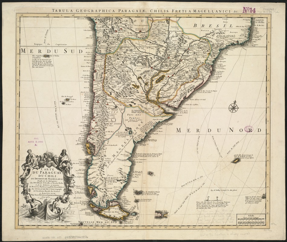
Carte du Paraguay, du Chili, du Detroit de Magellan &c
Item Information
- Title:
- Carte du Paraguay, du Chili, du Detroit de Magellan &c
- Title (alt.):
-
Tabula geographica Paragaiae, Chilis, freti a Magellanici & c
- Creator:
- L'Isle, Guillaume de, 1675-1726
- Name on Item:
-
dressée sur les descriptions des P.P. Alfonse d'Ovalle, et Nicolas Techo et sur les relations et memoires de Brouwer, Narbourg, Mr. de Beauchesne & par Guillaume de L'Isle.
- Date:
-
[1721?]
- Format:
-
Maps/Atlases
- Location:
-
Boston Public Library
Norman B. Leventhal Map & Education Center - Collection (local):
-
Norman B. Leventhal Map & Education Center Collection
- Subjects:
-
Paraguay--Maps--Early works to 1800
Chile--Maps--Early works to 1800
Argentina--Maps--Early works to 1800
Uruguay--Maps--Early works to 1800
Magellan, Strait of (Chile and Argentina)--Maps--Early works to 1800
South America--Maps--Early works to 1800
- Places:
-
Argentina
Uruguay
ChileMagallanes y de la Antártica Chilena (region)Magellan, Strait of
South America
Paraguay
South America
- Extent:
- 1 map ; 47 x 56 cm.
- Terms of Use:
-
No known copyright restrictions.
No known restrictions on use.
- Publisher:
-
A Amsteldam :
Iean Covens et Corneille Mortier
- Scale:
-
Scale [ca. 1:93,442].
- Language:
-
French
- Notes:
-
Relief shown pictorially.
Originally published by de L'Isle in 1703. Copied by Pieter Mortier around 1708 and published by Covens & Mortier after 1721.
Shows modern day Chile, Argentina, Paraguay, Uruguay and southern Brazil.
Cataloging, conservation, and digitization made possible in part by The National Endowment for the Humanities: Exploring the human endeavor.
- Identifier:
-
06_01_006471
- Call #:
-
G5200 1721 .L57
- Barcode:
-
39999059025856