A Mercators chart
This map is also available in American Revolutionary Geographies Online (ARGO), a collections portal especially built for material relating to the American Revolutionary War Era. Visit ARGO to learn more about this item and explore the historical geography of North America in the late eighteenth century.
Item Information
- Title:
- A Mercators chart
- Description:
-
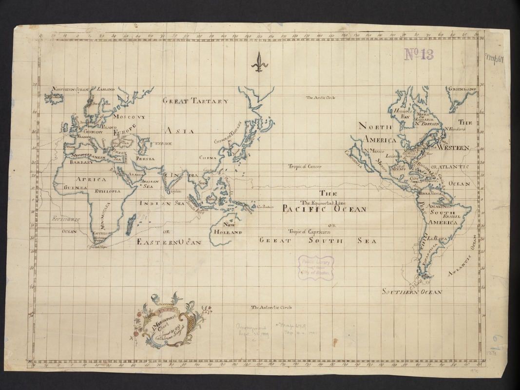
With a floral design embellishing its title cartouche and the use of stylized lettering and boundary symbols, this manuscript map of the world, most likely represents a geography project by a late-18th-century Boston schoolgirl. During the latter decades of the 18th century and the early part of the 19th century, it was common practice for British and American female students to prepare maps of various parts of the world from patterned samples. Schoolgirls also made cloth samplers, embroidering the lettering and boundaries as outlined on their patterns. Such projects were designed to combine instruction in both geography and needlework. There are several characteristics of this map which are unusual for the time period. In contrast to most 18th-century world maps which used a double hemisphere projection, this sample was based on the Mercator projection. In addition, the geographical features as outlined on the map were quite out of date -- California as an island rarely appeared on maps after the first third of the 18th century. Interestingly, this presentation was centered on the 150th degree of longitude east of the Greenwich (London) Prime Meridian, rather than the Greenwich meridian itself. Consequently, the central focus was the Pacific Ocean and the East Indies, which brings the reader's attention to a ship's track crossing the Pacific near the Equator. Although this track was not identified, it is the course of British Commodore George Anson's voyage around the world from 1741-1744. Anson's circumnavigation was the most important British voyage between Sir Francis Drake and Captain James Cook, primarily because of the extensive treasures that he captured from the Spanish galleons.
- Creator:
- Sargent, Catharine.
- Name on Item:
-
Catharine Sargent.
- Date:
-
1791
- Format:
-
Maps/Atlases
Manuscripts
- Location:
-
Boston Public Library
Norman B. Leventhal Map & Education Center - Collection (local):
-
Norman B. Leventhal Map & Education Center Collection
- Subjects:
-
World maps--Early works to 1800
- Places:
-
World
- Extent:
- 1 ms. map : col. ; 41 x 51 cm.
- Terms of Use:
-
No known copyright restrictions.
No known restrictions on use.
- Scale:
-
Scale not given.
- Language:
-
English
- Notes:
-
Exhibited in “Journeys of the Imagination,” at the Boston Public Library, Boston, MA, April - August 2006. MB (BRL)
- Notes (exhibitions):
-
Exhibited: "Back to School: Geography in the Classroom" organized by the Norman B. Leventhal Map Center at the Boston Public Library, 2014-2015.
- Identifier:
-
06_01_000021
- Call #:
-
G3200 1791 .S2
- Barcode:
-
39999052507785


