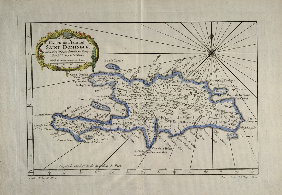
Carte de l'isle de Saint Domingue
This map is also available in American Revolutionary Geographies Online (ARGO), a collections portal especially built for material relating to the American Revolutionary War Era. Visit ARGO to learn more about this item and explore the historical geography of North America in the late eighteenth century.
Item Information
- Title:
- Carte de l'isle de Saint Domingue
- Title (alt.):
-
Isle de Saint Domingue
- Description:
-
Although no border between French and Spanish territory is indicated on this map (no official border existed until 1777), the uneasy sharing of the island of Hispaniola, or Santo Domingo, by the French and the Spanish colonial governments is evident in the island's place names. In the east, today's Dominican Republic, French names are used for coastal features, while the Spanish names used today are given for towns and churches. In the west, only French names are used. By the time this map was printed, the Spanish had ceded the western third of the island to the French. Spain would soon regret the concession, since what would later be known as Haiti was showing great promise in the sugar trade. This topographical map of Santo Domingo features mountains and rivers in addition to coastal features and towns. It was published in volume 15 of A. F. Prevost's "Histoires Generale des Voyages". Longitude is measured west from Paris, and the scale is given in standard French units. Since this map was engraved during a period of strong colonialism on the island, and the original inhabitants were nearly extinct due to war and disease, there is little sign of the original Taino place names -- one remaining example is the Yaqui River near the center of the island.
- Creator:
- Bellin, Jacques Nicolas, 1703-1772
- Name on Item:
-
par M. B. ing. de la marine, pour servir a l'histoire générale des voyages.
- Date:
-
1750
- Format:
-
Maps/Atlases
- Location:
-
Boston Public Library
Norman B. Leventhal Map & Education Center - Collection (local):
-
Norman B. Leventhal Map & Education Center Collection
- Subjects:
-
Haiti--Maps--Early works to 1800
Hispaniola--Maps--Early works to 1800
- Places:
-
Haiti
Hispaniola (island)
- Extent:
- 1 map : col. ; 32 x 22 cm.
- Terms of Use:
-
No known copyright restrictions.
No known restrictions on use.
- Publisher:
-
Paris :
[s.n.]
- Scale:
-
Scale not given.
- Language:
-
French
- Notes:
-
Relief shown pictorially.
Longitude west of Paris.
"Tome 15 in 8?. Page 257."
"Tom. XV. in 4?. n?. 10."
Exhibited in “Faces and Places,” at the Boston Public Library, Boston, MA, October 2003 - September 2004. MB (BRL)
- Identifier:
-
05_04_000146
- Call #:
-
G4930 1750 .B4
- Barcode:
-
39999052509682