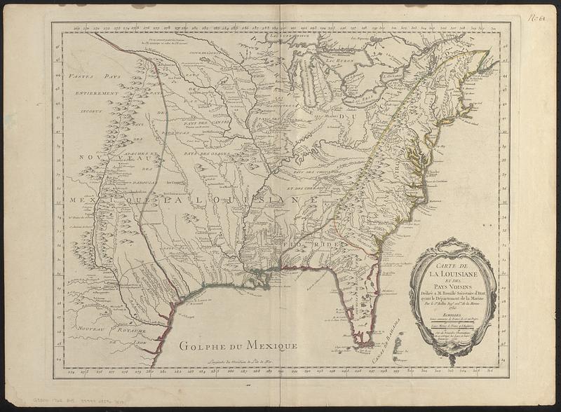
Carte de la Louisiane et des pays voisins dédiée à M. Rouillé sécretaire d'état, ayant le Département de la marine
This map is also available in American Revolutionary Geographies Online (ARGO), a collections portal especially built for material relating to the American Revolutionary War Era. Visit ARGO to learn more about this item and explore the historical geography of North America in the late eighteenth century.
Item Information
- Title:
- Carte de la Louisiane et des pays voisins dédiée à M. Rouillé sécretaire d'état, ayant le Département de la marine
- Cartographer:
- Bellin, Jacques Nicolas, 1703-1772
- Name on Item:
-
par le Sr. Bellin ingr. ordre. de la marine, 1750
- Date:
-
[1755–1762]
- Format:
-
Maps/Atlases
- Location:
-
Boston Public Library
Norman B. Leventhal Map & Education Center - Collection (local):
-
Norman B. Leventhal Map & Education Center Collection
- Subjects:
-
Great Britain--Territories and possessions--Maps
France--Territories and possessions--Maps
Spain--Territories and possessions--Maps
North America--Maps--Early works to 1800
Louisiana--Maps--Early works to 1800
- Places:
-
United States
- Extent:
- 1 map : hand color ; 45 x 58 cm
- Terms of Use:
-
No known copyright restrictions.
No known restrictions on use.
- Place of origin:
-
[Paris?]
- Scale:
-
Scale approximately 1:6,000,000
- Language:
-
French
- Notes:
-
Relief shown pictorially.
Prime meridian: L'ile de Fer.
"Sur de nouvelles observations on a corrigé les lacs, et leurs environs, 1755."
Hand colored boundaries outlining British, French, and Spanish territories.
- Notes (date):
-
This date is inferred.
- Notes (citation):
-
LC Maps of North America, 1750-1789, 90
McCorkle, B.B. New England in early printed maps, 1513 to 1800, 755.3
- Identifier:
-
06_01_018435
- Call #:
-
G3300 1762 .B45
- Barcode:
-
39999085967519


