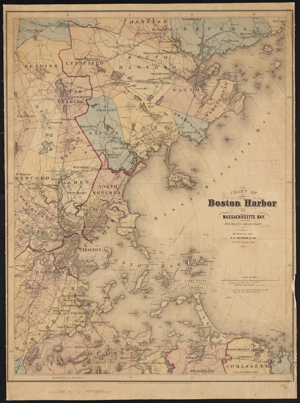
Chart of Boston Harbor and Massachusetts Bay : with map of the adjacent country
Item Information
- Title:
- Chart of Boston Harbor and Massachusetts Bay : with map of the adjacent country
- Creator:
- E.P. Dutton (Firm)
- Date:
-
1865
- Format:
-
Maps/Atlases
- Location:
-
Boston Public Library
Norman B. Leventhal Map & Education Center - Collection (local):
-
Norman B. Leventhal Map & Education Center Collection
- Subjects:
-
Boston Harbor (Mass.)--Maps
Massachusetts Bay (Mass.)--Maps
Massachusetts--Maps
- Places:
-
MassachusettsBoston Harbor
MassachusettsMassachusetts Bay
- Extent:
- 1 map : hand col. ; 61 x 48 cm.
- Terms of Use:
-
No known copyright restrictions.
No known restrictions on use.
- Publisher:
-
[Boston] :
[Pub. at] the Boston Map Store [by] E.P. Dutton & Co.
- Scale:
-
Scale [ca. 1:65,400]
- Language:
-
English
- Notes:
-
Shows location of buoys, beacons, rocks, etc.
Relief shown by hachures.
Prime meridian: State House (Boston).
In center lower margin: Entered according to Act of Congress in the year 1861 by E.P. Dutton & Co. in the Clerks Office of the District Court in the District of Massachusetts.
Shows radial distances from the State House in Boston.
- Identifier:
-
06_01_002670
- Call #:
-
G3762.B65 1861 .E6
- Barcode:
-
39999058996917


