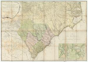
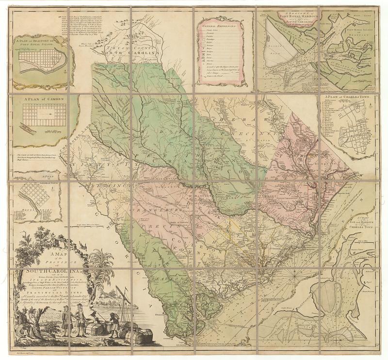
A map of the province of South Carolina with all the rivers, creeks, bays, inletts, islands, inland navigation, soundings, time of high water on the sea coast, roads, marshes, ferrys, bridges, swamps, parishes churches, towns, townships; county parish district and provincial lines
This map is also available in American Revolutionary Geographies Online (ARGO), a collections portal especially built for material relating to the American Revolutionary War Era. Visit ARGO to learn more about this item and explore the historical geography of North America in the late eighteenth century.
Item Information
- Title:
- A map of the province of South Carolina with all the rivers, creeks, bays, inletts, islands, inland navigation, soundings, time of high water on the sea coast, roads, marshes, ferrys, bridges, swamps, parishes churches, towns, townships; county parish district and provincial lines
- Creator:
- Cook, James, 1728-1779
- Publisher:
- Bowen, Thomas, -1790
- Name on Item:
-
humbly inscribed to the hon.ble Lawlins Lowndes, esq.r speaker & the rest of the members of the hon.ble the Commons House of Assembly of the province by their most obed.t & faithfull serv.t Jam.s Cook ; Tho.s Bowen, sculp.t
- Date:
-
[ca. 1773]
- Format:
-
Maps/Atlases
- Location:
- MacLean Collection Map Library
- Collection (local):
-
MacLean Collection Map Library
- Subjects:
-
South Carolina--Maps--Early works to 1800
- Places:
-
South Carolina
- Extent:
- 1 map ; folded to 197 x 140 mm, case 204 x 147 mm
- Terms of Use:
-
Public Domain/No known restrictions on use. Contact host institution to download image.
Contact host institution for more information.
- Publisher:
-
London :
Bowen, Thomas
- Language:
-
English
- Identifier:
-
MC_1014
- Call #:
-
1014