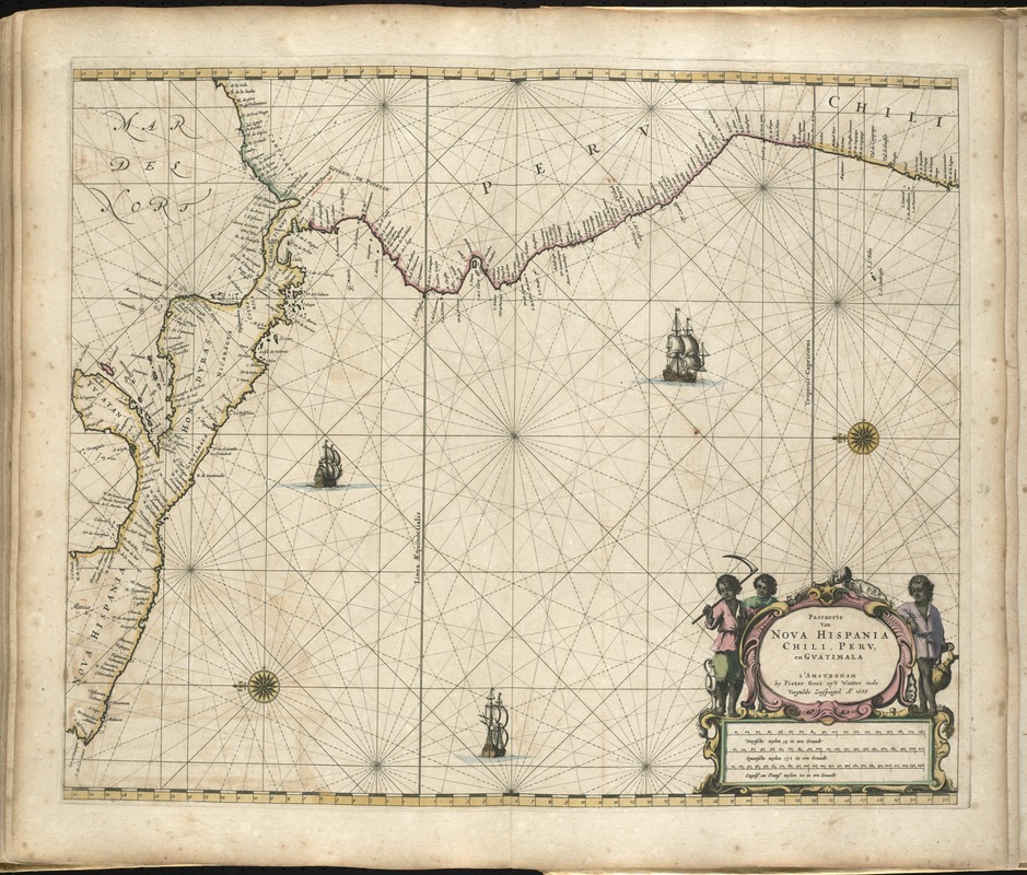
Pascaerte van Nova Hispania, Chili, Peru, en Guatimala
Item Information
- Title:
- Pascaerte van Nova Hispania, Chili, Peru, en Guatimala
- Creator:
- Goos, Pieter, ca. 1616-1675
- Date:
-
1672
- Format:
-
Maps/Atlases
- Location:
-
Boston Public Library
Norman B. Leventhal Map & Education Center - Collection (local):
-
Norman B. Leventhal Map & Education Center Collection
- Subjects:
-
Coasts--Central America--Maps--Early works to 1800
Coasts--South America--Maps--Early works to 1800
Nautical charts--South America--Early works to 1800
Nautical charts--Central America--Early works to 1800
Central America--Maps--Early works to 1800
South America--Maps--Early works to 1800
Pacific Coast (South America)--Maps--Early works to 1800
Pacific Coast (Central America)--Maps--Early works to 1800
- Places:
-
Mesoamerica (area)
South America
South America
- Extent:
- 1 map : hand col. ; 43 x 55 cm.
- Terms of Use:
-
No known copyright restrictions.
No known restrictions on use.
- Publisher:
-
t'Amsteldam :
By Pieter Goos
- Scale:
-
Scale [ca. 1:11,000,000].
- Language:
-
Dutch
- Notes:
-
Nautical chart showing the coastline of Central America, Peru, and Chile.
Oriented with north to the left.
Appears in the author's De zee-atlas ofte water-wereld. t'Amsteldam : By Pieter Goos, 1672.
Cataloging, conservation, and digitization made possible in part by The National Endowment for the Humanities: Exploring the human endeavor.
Atlas scanned by Internet Archive http://archive.org/details/dezeeatlasoftewa00goos
- Identifier:
-
06_01_007930
- Call #:
-
G1059 .G66 1672
- Barcode:
-
30000003773872