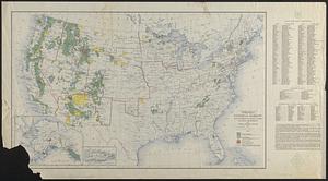
United States, including territories and insular possessions : showing the extent of public surveys, national parks, national forests, Indian reservations, national wildlife refuges, and reclamation projects

Item Information
- Title:
- United States, including territories and insular possessions : showing the extent of public surveys, national parks, national forests, Indian reservations, national wildlife refuges, and reclamation projects
- Cartographer:
- United States. Bureau of Land Management
- Name on Item:
-
United States Department of the Interior, Bureau of Land Management
- Date:
-
1954
- Format:
-
Maps/Atlases
- Location:
-
Boston Public Library
Norman B. Leventhal Map & Education Center - Collection (local):
-
Norman B. Leventhal Map & Education Center Collection
- Subjects:
-
United States--Surveys--Maps
United States--Territorial expansion--Maps
Public lands--United States--Maps
- Places:
-
United States
- Extent:
- 1 map on 2 sheets : color ; 148 x 205 cm, on sheets 161 x 109 cm
- Terms of Use:
-
No known copyright restrictions.
No known restrictions on use.
- Publisher:
-
Washington D.C. :
Interior - Geological Survey
- Scale:
-
Scale 1:2,344,320. 37 miles to 1 inch
- Language:
-
English
- Notes:
-
Also shows territorial growth with dates of acquisition.
Insets: Alaska -- American Samoa (with inset of Manua Group) -- Guam or Cuajan Island -- Palmyra Island -- Hawaiian Islands -- Puerto Rico and the Virgin Islands of the U.S. -- Canal Zone (with inset of Isthmus of Panama showing location of canal) -- Pacific Islands under United States sovereignty (Canton Island -- Midway Island -- Wake Island -- Enderbury Island -- Howland Island -- Jarvis Island -- Baker Island) -- [Location map].
Relief shown by hachures and spot heights.
"Original base engraved by R.F. Bartle & Co., Washington, D.C."
- Identifier:
-
06_01_018548
- Call #:
-
G3701.B5 1953 .U5
- Barcode:
-
39999085968756