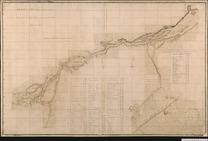
Plan des forts de Chouaguen avec le débarquement, le camp et les attaques de l'armée commandée par Mr le Marquis de Montcalm, Jean-Nicolas Desandrouins [Oswego]
![Plan des forts de Chouaguen avec le débarquement, le camp et les attaques de l'armée commandée par Mr le Marquis de Montcalm, Jean-Nicolas Desandrouins [Oswego]](https://bpldcassets.blob.core.windows.net/derivatives/images/commonwealth:5138nc68v/image_access_800.jpg)
This map is also available in American Revolutionary Geographies Online (ARGO), a collections portal especially built for material relating to the American Revolutionary War Era. Visit ARGO to learn more about this item and explore the historical geography of North America in the late eighteenth century.
Item Information
- Title:
- Plan des forts de Chouaguen avec le débarquement, le camp et les attaques de l'armée commandée par Mr le Marquis de Montcalm, Jean-Nicolas Desandrouins [Oswego]
- Cartographer:
- Desandroüins, Jean Nicolas, 1729-1792
- Date:
-
1756
- Format:
-
Maps/Atlases
- Genre:
-
Manuscript maps
- Location:
- Library and Archives Canada
- Collection (local):
-
Library and Archives Canada Collection
- Subjects:
-
Seven Years' War, 1756-1763--Campaigns--Canada--Maps
Oswego (N.Y.)--Maps
New France--Maps
- Places:
-
Oswego (county)Oswego
New France
- Extent:
- 1 manuscript map : hand color ; 60 x 98 cm
- Terms of Use:
-
Copyright expired. Contact host institution to download image.
Contact host institution for more information.
- Place of origin:
-
[Oswego]
- Language:
-
French
- Catalog Record:
-
Catalog record
- Identifier:
-
e011182111
- Barcode:
-
4139827