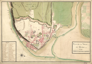
Plan of Quebec, the capital of Canada in North America, with the bason and part of the adjacent contry [sic] shewing the principal encampments and works of the British Army commanded by Maior General Wolfe and those of the French Army commanded by Lieut. General, the Marquis of Mont Calm during the siege of that place in 1759 [overlay down]
![Plan of Quebec, the capital of Canada in North America, with the bason and part of the adjacent contry [sic] shewing the principal encampments and works of the British Army commanded by Maior General Wolfe and those of the French Army commanded by Lieut. General, the Marquis of Mont Calm during the siege of that place in 1759 [overlay down]](https://bpldcassets.blob.core.windows.net/derivatives/images/commonwealth:q524nd83b/image_access_800.jpg)
This map is also available in American Revolutionary Geographies Online (ARGO), a collections portal especially built for material relating to the American Revolutionary War Era. Visit ARGO to learn more about this item and explore the historical geography of North America in the late eighteenth century.
Item Information
- Title:
- Plan of Quebec, the capital of Canada in North America, with the bason and part of the adjacent contry [sic] shewing the principal encampments and works of the British Army commanded by Maior General Wolfe and those of the French Army commanded by Lieut. General, the Marquis of Mont Calm during the siege of that place in 1759 [overlay down]
- Date:
-
1759
- Format:
-
Maps/Atlases
Manuscripts
- Location:
- Library of Congress Geography and Map Division
- Collection (local):
-
Library of Congress Collection
- Subjects:
-
Québec Campaign, Québec, 1759--Maps, Manuscript--Early works to 1800
Québec (Québec)--Maps, Manuscript--Early works to 1800
- Places:
-
CanadaQuébec
- Extent:
- 1 ms. map : col. ; 91 x 151 cm.
- Terms of Use:
-
No known copyright restrictions.
This work is licensed for use under a Creative Commons Attribution Non-Commercial Share Alike License (CC BY-NC-SA).

- Scale:
-
Scale [1:9,600]
- Language:
-
English
- Catalog Record:
-
https://lccn.loc.gov/2005630163
- Notes:
-
Relief shown by shading.
"NB. The British works are coloured yellow and thier [sic] encampments red with the faceings [sic] of the different corpes [sic]. The French works and encampments are coloured blue."
"N.B. The different parts were surveyed as follows viz, the east side of the Falls of Montmorency, the Point of Orleans, and the south side of the River St. Lawrence by Capt. Debbieg, engineer in ordinary. The coast of Beauport from the River St. Charles to the Falls of Montmorency by Capt. Holland of the Royal Americans as engineer. The ground between the River St. Lawrence and the River St. Charles by Lieutenant Des Barres of the Roy. Americans as eng.
Pen-and-ink and watercolor.
A small map showing "Encampment and works after the battle of the 13th" affixed to the left border over the area "Hauteur D'Abraham" prior to the battle.
Includes text and index.
- Identifier:
-
ar303300Zb

![Plan of Quebec, the capital of Canada in North America, with the bason and part of the adjacent contry [sic] shewing the principal encampments and works of the British Army commanded by Maior General Wolfe and those of the French Army commanded by Lieut. General, the Marquis of Mont Calm during the siege of that place in 1759 [overlay up]](https://bpldcassets.blob.core.windows.net/derivatives/images/commonwealth:q524nd81s/image_thumbnail_300.jpg)
![[Map of Quebec and environs showing the position of the English and French troops]](https://bpldcassets.blob.core.windows.net/derivatives/images/commonwealth:hx11xz61s/image_thumbnail_300.jpg)
